Parkview Mountain
Parkview Mountain is the highest summit of the Rabbit Ears Range in the Rocky Mountains of North America. The mountain is on the Continental Divide in Routt National Forest about 3 miles (4.8 km) southwest of Willow Creek Pass.
| Parkview Mountain | |
|---|---|
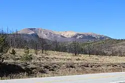 The mountain, viewed from State Highway 125, also showing damage from the 2020 East Troublesome Fire | |
| Highest point | |
| Elevation | 12,301 ft (3,749 m)[1][2] |
| Prominence | 2,676 ft (816 m)[3] |
| Isolation | 10.91 mi (17.56 km)[3] |
| Listing | Colorado prominent summits Colorado range high points |
| Coordinates | 40°19′49″N 106°08′11″W[1] |
| Geography | |
 Parkview Mountain | |
| Location | Grand and Jackson counties, Colorado, U.S.[4] |
| Parent range | Highest summit of the Rabbit Ears Range[3] |
| Topo map | USGS 7.5' topographic map Parkview Mountain, Colorado[1] |
| Climbing | |
| Easiest route | hike |
From the summit a climber can see both Middle Park to the south and North Park to the North, hence the name of the Peak.
See also
- List of Colorado mountain ranges
- List of Colorado mountain summits
- List of Colorado fourteeners
- List of Colorado 4000 meter prominent summits
- List of the most prominent summits of Colorado
- List of Colorado county high points
References
- "PARKVIEW MOUNTAIN". NGS Data Sheet. National Geodetic Survey, National Oceanic and Atmospheric Administration, United States Department of Commerce. Retrieved October 21, 2014.
- The elevation of Parkview Mountain includes an adjustment of +1.589 m (+5.21 ft) from NGVD 29 to NAVD 88.
- "Parkview Mountain, Colorado". Peakbagger.com. Retrieved October 21, 2014.
- "Parkview Mountain". Geographic Names Information System. United States Geological Survey, United States Department of the Interior. Retrieved October 29, 2014.
External links
 Media related to Parkview Mountain at Wikimedia Commons
| Book Cliffs |
| ||||||||||
|---|---|---|---|---|---|---|---|---|---|---|---|
| Elk Mountains |
| ||||||||||
| Elkhead Mountains |
| ||||||||||
| Flat Tops |
| ||||||||||
| Front Range | |||||||||||
| Gore Range |
| ||||||||||
| Grand Mesa |
| ||||||||||
| Laramie Mountains |
| ||||||||||
| Medicine Bow Mountains | |||||||||||
| Mosquito Range |
| ||||||||||
| Park Range | |||||||||||
| Rabbit Ears Range |
| ||||||||||
| Raton Mesa | |||||||||||
| San Juan Mountains |
| ||||||||||
| Sangre de Cristo Mountains |
| ||||||||||
| Sawatch Range |
| ||||||||||
| Spanish Peaks | |||||||||||
| Tenmile Range |
| ||||||||||
| Uinta Mountains |
| ||||||||||
| West Elk Mountains |
| ||||||||||
| Others |
| ||||||||||
| Federal | |||||||||||
|---|---|---|---|---|---|---|---|---|---|---|---|
| State |
| ||||||||||
| Trails |
| ||||||||||
This article is issued from Wikipedia. The text is licensed under Creative Commons - Attribution - Sharealike. Additional terms may apply for the media files.