Petit Grepon
Petit Grepon is a semi-detached spire in Colorado's Rocky Mountain National Park. It is one of the "Cathedral Spires" which also includes: Sharkstooth, The Saber, and The Foil. The South Face route of Petit Grepon is described in the historic climbing text Fifty Classic Climbs of North America[3] and considered a classic around the world.[4]
| Petit Grepon | |
|---|---|
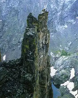 Climbers atop Petit Grepon, as seen from The Sharkstooth | |
| Highest point | |
| Elevation | 12,305 ft (3,751 m)[1][2] |
| Prominence | 300 ft (91 m)[2] |
| Isolation | 0.04 mi (0.064 km)[2] |
| Coordinates | 40°16′52″N 105°40′26″W[2] |
| Geography | |
 Petit Grepon | |
| Location | Rocky Mountain National Park, Larimer County, Colorado, U.S.[2] |
| Parent range | Front Range[2] |
| Topo map | USGS 7.5' topographic map McHenrys Peak, Colorado[2] |
| Climbing | |
| First ascent | Bill Buckingham & Art Davidson, 1961. |
Climate
According to the Köppen climate classification system, the spire is located in an alpine subarctic climate zone with cold, snowy winters, and cool to warm summers.[5] Due to its altitude, it receives precipitation all year, as snow in winter, and as thunderstorms in summer, with a dry period in late spring.
See also
- List of Colorado mountain ranges
- List of Colorado mountain summits
- List of Colorado fourteeners
- List of Colorado 4000 meter prominent summits
- List of the most prominent summits of Colorado
- List of Colorado county high points
References
- The elevation of Petit Grepon includes an adjustment of +1.608 m (+5.28 ft) from NGVD 29 to NAVD 88.
- "Petit Grepon, Colorado". Peakbagger.com. Retrieved November 4, 2014.
- Roper, Steve; Steck, Allen (1979). Fifty Classic Climbs of North America. San Francisco: Sierra Club Books. ISBN 0-87156-292-8.
- Stewart M. Green (1995). Rock Climbing Colorado. Falcon Guides. ISBN 1-56044-334-0.
- Peel, M. C.; Finlayson, B. L.; McMahon, T. A. (2007). "Updated world map of the Köppen−Geiger climate classification". Hydrol. Earth Syst. Sci. 11. ISSN 1027-5606.
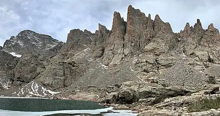
Cathedral Spires seen from Sky Pond. The apparent highest spire is "Saber" and immediately left of it is Petit Grepon. At far left edge is Taylor Peak.
External links
| Book Cliffs |
| ||||||||||
|---|---|---|---|---|---|---|---|---|---|---|---|
| Elk Mountains |
| ||||||||||
| Elkhead Mountains |
| ||||||||||
| Flat Tops |
| ||||||||||
| Front Range | |||||||||||
| Gore Range |
| ||||||||||
| Grand Mesa |
| ||||||||||
| Laramie Mountains |
| ||||||||||
| Medicine Bow Mountains | |||||||||||
| Mosquito Range |
| ||||||||||
| Park Range | |||||||||||
| Rabbit Ears Range |
| ||||||||||
| Raton Mesa | |||||||||||
| San Juan Mountains |
| ||||||||||
| Sangre de Cristo Mountains |
| ||||||||||
| Sawatch Range |
| ||||||||||
| Spanish Peaks | |||||||||||
| Tenmile Range |
| ||||||||||
| Uinta Mountains |
| ||||||||||
| West Elk Mountains |
| ||||||||||
| Others |
| ||||||||||
| Federal | |||||||||||
|---|---|---|---|---|---|---|---|---|---|---|---|
| State |
| ||||||||||
| Trails |
| ||||||||||
This article is issued from Wikipedia. The text is licensed under Creative Commons - Attribution - Sharealike. Additional terms may apply for the media files.