X
This article was co-authored by wikiHow Staff. Our trained team of editors and researchers validate articles for accuracy and comprehensiveness. wikiHow's Content Management Team carefully monitors the work from our editorial staff to ensure that each article is backed by trusted research and meets our high quality standards.
This article has been viewed 9,526 times.
Learn more...
The Google Maps app allows you to find walking, driving and public transit directions online. This wikiHow shows you how to download directions via the Google Maps app so that you can access them even if you can't connect to the internet.
Steps
-
1Open the Google Maps app. The icon is green, blue, yellow and red and has a small letter "G" in the upper left corner.
-
2Tap on the search bar and enter a location. The location you entered appears at the bottom of the screen.
- Google Maps accepts a wide variety of specific and general locations. You can enter a street name, an address, the name of a business establishment, or even the name of a city.
Advertisement -
3Tap the name of the location at the bottom of the screen. This opens a tab with greater detail on the location.
-
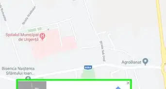
4Tap ••• in the top right corner of the screen. The More icon is represented by three dots in a horizontal line.
-
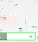
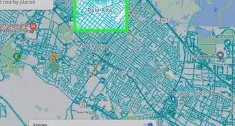
5Tap Download offline map. Google Maps shows you a map of the location and asks you to confirm that you wish to download it. You can zoom in or out here to reduce or expand the area that the map covers.
-
6Tap Download. The map is downloaded to your device.
- Once a map is downloaded, you can get basic directions from that map even if your device has no internet access.
- Offline map functionality is somewhat limited. Driving directions won't include traffic information or alternative routes, and specific transit, walking and bicycling directions are not available.[1]


Advertisement


About This Article

wikiHow Staff
wikiHow Staff Writer
This article was co-authored by wikiHow Staff. Our trained team of editors and researchers validate articles for accuracy and comprehensiveness. wikiHow's Content Management Team carefully monitors the work from our editorial staff to ensure that each article is backed by trusted research and meets our high quality standards. This article has been viewed 9,526 times.
How helpful is this?
Co-authors: 3
Updated: March 29, 2019
Views: 9,526
Categories: Google Maps
Advertisement