This article was co-authored by wikiHow staff writer, Nicole Levine, MFA. Nicole Levine is a Technology Writer and Editor for wikiHow. She has more than 20 years of experience creating technical documentation and leading support teams at major web hosting and software companies. Nicole also holds an MFA in Creative Writing from Portland State University and teaches composition, fiction-writing, and zine-making at various institutions.
This article has been viewed 48,077 times.
Learn more...
This wikiHow teaches you how to find the estimated elevation of an area in Google Maps. Maps does not report elevations for most locations, but you can use Terrain View to find estimates for mountainous areas.
Steps
-
1Go to https://maps.google.com in a web browser. You can use any web browser on your computer to access Google Maps.
-
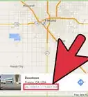
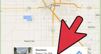
2Search for a location. Type an address or landmark into the search bar at the top-left corner of the map, then click it when it appears in the results.
- Google Maps does not report the exact elevation for all areas. You’ll only be able to find an estimate when you’re viewing a mountainous area.
- You can also drag the map around with the mouse until you’ve found the right spot.
Advertisement -
3Click the ≡ menu. It’s at the top-left corner of the page.
-
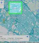
4Click Terrain. This switches the map to a view that shows the dips and highs of the location.
-
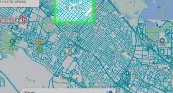
5Zoom into a hilly area. Click + at the bottom-right corner of the map to zoom in until you see light gray contour lines surrounding the hills and peaks. Estimated elevations appear along many of these lines (in light gray text) at various intervals.
- If you zoom in too far, you won’t see the contour lines or estimated elevations. Click the - button at the bottom-right corner of the map to zoom out.


About This Article

1. Open Google Maps.
2. Search for a location.
3. Click ≡.
4. Click Terrain.
5. Zoom into a hilly area.