Hexigten Banner
Hexigten Banner (Mongolian script: ᠬᠡᠰᠢᠭᠲᠡᠨ ᠬᠣᠰᠢᠭᠤ; Chinese: 克什克腾旗) is a banner of Inner Mongolia, China under the jurisdiction of Chifeng, bordering Hebei province to the south. In 1690 the Battle of Ulan Butung between Qing and Dzungar forces took place here.
Hexigten Banner
克什克腾旗 • ᠬᠡᠰᠢᠭᠲᠡᠨᠬᠣᠰᠢᠭᠤ | |
|---|---|
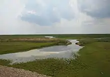
 Grasslands in the summer | |
 Heshigten Location of the seat in Inner Mongolia | |
| Coordinates: 43°16′48″N 117°28′48″E | |
| Country | People's Republic of China |
| Autonomous region | Inner Mongolia |
| Prefecture-level city | Chifeng |
| Area | |
| • Total | 20,637 km2 (7,968 sq mi) |
| Elevation | 1,100 m (3,600 ft) |
| Population (2020) | |
| • Total | 186,143 |
| • Density | 9.0/km2 (23/sq mi) |
| Time zone | UTC+8 (China Standard) |
| Postal code | 025350 |
| Area code | 0476 |
| Hexigten Banner | |||||||
|---|---|---|---|---|---|---|---|
| Chinese name | |||||||
| Simplified Chinese | 克什克腾旗 | ||||||
| Traditional Chinese | 克什克騰旗 | ||||||
| |||||||
| Mongolian name | |||||||
| Mongolian Cyrillic | Кэсигтэн қосиу | ||||||
| Mongolian script | ᠬᠡᠰᠢᠭᠲᠡᠨ ᠬᠣᠰᠢᠭᠤ | ||||||
| |||||||
Etymology

It was named after the Khishigten Mongol clan, who were considered to be the descendants of the Kheshig, the imperial guard of the Mongol Empire.
Demographics
There are 8 main ethnic groups (i.e. Han, Mongol, Hui, Manchu, Daur, Korean, Dong and Zhuang). The Mongols are of the Hishigten division.
Climate
| Climate data for Hexigten Banner (1981−2010) | |||||||||||||
|---|---|---|---|---|---|---|---|---|---|---|---|---|---|
| Month | Jan | Feb | Mar | Apr | May | Jun | Jul | Aug | Sep | Oct | Nov | Dec | Year |
| Record high °C (°F) | 4.0 (39.2) |
14.2 (57.6) |
22.3 (72.1) |
31.5 (88.7) |
34.7 (94.5) |
36.2 (97.2) |
37.8 (100.0) |
35.6 (96.1) |
33.4 (92.1) |
26.8 (80.2) |
20.4 (68.7) |
11.6 (52.9) |
37.8 (100.0) |
| Average high °C (°F) | −10.7 (12.7) |
−5.6 (21.9) |
2.5 (36.5) |
13.1 (55.6) |
20.4 (68.7) |
24.9 (76.8) |
26.8 (80.2) |
25.6 (78.1) |
20.5 (68.9) |
12.3 (54.1) |
0.8 (33.4) |
−7.9 (17.8) |
10.2 (50.4) |
| Daily mean °C (°F) | −16.7 (1.9) |
−12.7 (9.1) |
−4.5 (23.9) |
5.5 (41.9) |
13.0 (55.4) |
17.9 (64.2) |
20.5 (68.9) |
18.6 (65.5) |
12.5 (54.5) |
4.4 (39.9) |
−5.9 (21.4) |
−13.7 (7.3) |
3.2 (37.8) |
| Average low °C (°F) | −21.5 (−6.7) |
−18.3 (−0.9) |
−10.6 (12.9) |
−1.5 (29.3) |
5.3 (41.5) |
10.9 (51.6) |
14.6 (58.3) |
12.4 (54.3) |
5.6 (42.1) |
−1.8 (28.8) |
−11.0 (12.2) |
−18.4 (−1.1) |
−2.9 (26.9) |
| Record low °C (°F) | −35.3 (−31.5) |
−31.3 (−24.3) |
−27.8 (−18.0) |
−17.1 (1.2) |
−5.4 (22.3) |
0.7 (33.3) |
4.8 (40.6) |
2.3 (36.1) |
−7.4 (18.7) |
−14.9 (5.2) |
−28.5 (−19.3) |
−33.2 (−27.8) |
−35.3 (−31.5) |
| Average precipitation mm (inches) | 2.7 (0.11) |
3.9 (0.15) |
7.4 (0.29) |
14.1 (0.56) |
36.2 (1.43) |
63.6 (2.50) |
108.0 (4.25) |
88.3 (3.48) |
40.1 (1.58) |
17.2 (0.68) |
7.0 (0.28) |
3.3 (0.13) |
391.8 (15.44) |
| Average relative humidity (%) | 66 | 62 | 53 | 42 | 44 | 57 | 67 | 69 | 61 | 54 | 58 | 65 | 58 |
| Source: China Meteorological Data Service Center[1] | |||||||||||||
Transport
- China National Highway 303
- China National Highway 306
- Hanbai Highway
- Jitong Railway
Economy
The main industries are mining, renewable energy, tourism, and stock breeding. From 2006 to 2008, Hexigten ranked No. 1 for 3 consecutive years in wind power production among all the counties of China with 532 wind turbines installed in 2008, totally installed generating capacity of 525 megawatt and annual energy generation of 1124 GWh.
Sights
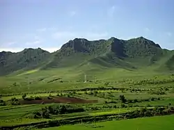
- Heshigten Global Geopark is one of the UNESCO Global Geoparks. Its 1,750 km2 area is contained in eight separate areas of scenic beauty and geologic significance, including volcanic, glacial, and desert features.
References
- 中国地面气候标准值月值(1981-2010) (in Simplified Chinese). China Meteorological Data Service Center. Retrieved 24 November 2022.