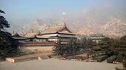
Tumed Right Banner
Tumed Right Banner (Mongolian: ᠲᠦᠮᠡᠳ
ᠪᠠᠷᠠᠭᠤᠨ
ᠬᠣᠰᠢᠭᠤ, romanized: Tumed Baruun Hôxûû, pronounced [ˈtumə̆d ˈbɑrʊːn ˈxɔʃʊː];[2] Chinese: 土默特右旗; pinyin: Tǔmòtè Yòuqí) is a banner of western Inner Mongolia, People's Republic of China. It is under the administration of Baotou City, 59 kilometres (37 mi) to the west, and is located along on the Jingzang Expressway, running from Beijing to Tibet.
Tumed Right Banner
土默特右旗 • ᠲᠦᠮᠡᠳᠪᠠᠷᠠᠭᠤᠨᠬᠣᠰᠢᠭᠤ | |
|---|---|
 | |
 Tumed Youqi Location in Inner Mongolia | |
| Coordinates: 40°34′N 110°31′E | |
| Country | People's Republic of China |
| Region | Inner Mongolia |
| Prefecture-level city | Baotou |
| Elevation | 1,007 m (3,304 ft) |
| Population (2020)[1] | |
| • Total | 237,421 |
| Time zone | UTC+8 (China Standard) |
Climate
| Climate data for Tumed Right Banner (1981−2010) | |||||||||||||
|---|---|---|---|---|---|---|---|---|---|---|---|---|---|
| Month | Jan | Feb | Mar | Apr | May | Jun | Jul | Aug | Sep | Oct | Nov | Dec | Year |
| Record high °C (°F) | 7.3 (45.1) |
16.0 (60.8) |
23.5 (74.3) |
35.2 (95.4) |
35.9 (96.6) |
39.8 (103.6) |
39.7 (103.5) |
35.0 (95.0) |
33.4 (92.1) |
27.8 (82.0) |
20.1 (68.2) |
11.2 (52.2) |
39.8 (103.6) |
| Average high °C (°F) | −3.8 (25.2) |
1.4 (34.5) |
8.6 (47.5) |
17.6 (63.7) |
24.2 (75.6) |
28.4 (83.1) |
29.4 (84.9) |
27.0 (80.6) |
22.7 (72.9) |
15.6 (60.1) |
5.7 (42.3) |
−2.0 (28.4) |
14.6 (58.2) |
| Daily mean °C (°F) | −10.5 (13.1) |
−5.5 (22.1) |
1.8 (35.2) |
10.3 (50.5) |
17.3 (63.1) |
21.8 (71.2) |
23.3 (73.9) |
21.1 (70.0) |
15.8 (60.4) |
8.5 (47.3) |
−0.7 (30.7) |
−8.2 (17.2) |
7.9 (46.2) |
| Average low °C (°F) | −16.4 (2.5) |
−11.6 (11.1) |
−4.2 (24.4) |
3.0 (37.4) |
9.8 (49.6) |
14.6 (58.3) |
17.3 (63.1) |
15.5 (59.9) |
9.6 (49.3) |
2.5 (36.5) |
−5.8 (21.6) |
−13.4 (7.9) |
1.7 (35.1) |
| Record low °C (°F) | −30.8 (−23.4) |
−28.3 (−18.9) |
−18.3 (−0.9) |
−8.4 (16.9) |
−2.5 (27.5) |
2.2 (36.0) |
10.4 (50.7) |
6.8 (44.2) |
−1.9 (28.6) |
−8.5 (16.7) |
−22.3 (−8.1) |
−30.9 (−23.6) |
−30.9 (−23.6) |
| Average precipitation mm (inches) | 1.5 (0.06) |
3.6 (0.14) |
10.7 (0.42) |
12.7 (0.50) |
33.5 (1.32) |
35.7 (1.41) |
91.6 (3.61) |
92.2 (3.63) |
47.3 (1.86) |
19.5 (0.77) |
4.4 (0.17) |
2.5 (0.10) |
355.2 (13.99) |
| Average relative humidity (%) | 58 | 51 | 45 | 38 | 40 | 48 | 62 | 67 | 62 | 56 | 57 | 58 | 54 |
| Source: China Meteorological Data Service Center[3] | |||||||||||||
See also
External links
- www.xzqh.org (in Chinese)
References
- Inner Mongolia: Prefectures, Cities, Districts and Counties
- ᠮᠣᠨᠭᠭᠣᠯ
ᠬᠢᠲᠠᠳ
ᠲᠣᠯᠢ / Měng-Hàn cídiǎn 《蒙汉词典》. Hohhot: ᠥᠪᠥᠷ
ᠮᠣᠨᠭᠭᠣᠯ ᠤᠨ
ᠶᠡᠬᠡ
ᠰᠤᠷᠭᠠᠭᠤᠯᠢ ᠶᠢᠨ
ᠬᠡᠪᠯᠡᠯ ᠤᠨ
ᠭᠣᠷᠢᠶ ᠠ / Nèi Ménggǔ Dàxué Chūbǎnshè 内蒙古大学出版社, 1999; ISBN 7-81074-000-8. - 中国地面气候标准值月值(1981-2010) (in Simplified Chinese). China Meteorological Data Service Center. Retrieved 24 November 2022.
This article is issued from Wikipedia. The text is licensed under Creative Commons - Attribution - Sharealike. Additional terms may apply for the media files.