Bima Regency
Bima Regency is a regency (Indonesian: Kabupaten) of the Indonesian Province of West Nusa Tenggara. It is located on the island of Sumbawa and the capital is Woha. The Regency covers an area of 4,389.40 km2, and had a population of 438,522 at the 2010 Census[2] and 514,105 at the 2020 Census;[3] the official estimate as at mid 2023 was 535,530 (comprising 269,048 males and 266,482 females).[1] It administratively excludes but geographically completely surrounds Bima City on the landward side.
Bima Regency
Kabupaten Bima | |
|---|---|
 Coat of arms | |
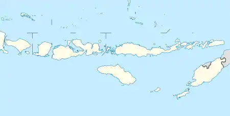
 Location within West Nusa Tenggara | |
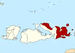
 Bima Regency Location in Lesser Sunda Islands and Indonesia  Bima Regency Bima Regency (Indonesia) | |
| Coordinates: 8°34′28″S 119°2′15″E | |
| Country | |
| Province | |
| Capital | Woha |
| Government | |
| • Regent | Indah Damayanti Putri |
| • Vice Regent | Dachlan Muhammad Noer |
| Area | |
| • Total | 4,389.40 km2 (1,694.76 sq mi) |
| Population (mid 2023 estimate)[1] | |
| • Total | 535,530 |
| • Density | 120/km2 (320/sq mi) |
| Time zone | UTC+8 (ICST) |
| Area code | (+62) 374 |
| Website | bimakab.go.id |
It has two non-contiguous parts, which are separated by the northeastern coastal portion of Dompu Regency. The larger eastern half of Bima Regency covers the easternmost quarter of the island (excluding Bima City), and comprises sixteen districts. This includes two substantial offshore islands (Sangeang Island to the northeast of Sumbawa and Banta Island to the east) and 89 smaller islands. The smaller western part of Bima Regency covers the northern half of the Sanggar Peninsula, which is dominated by Mount Tambora, and comprises Sanggar District and Tambora District; to the north-east of this part is Sanggar Bay. Three bodies of water border the regency - Bima Bay, Waworada Bay, and Sape Strait.
The Regency is nearly co-terminus with the former Sultanate of Bima and includes the nearby islands of Sangeang, Banta, and Managate. The island of Kambing, which lies in Bima Bay, is also part of the Regency.
Administrative Districts
Bima Regency consists of eighteen districts (kecamatan), tabulated below with their areas and their populations at the 2010 Census[2] and the 2020 Census,[3] together with the official estimates as at mid 2023.[1] The table also includes the locations of the district administrative centres, the number of administrative villages (all classed as rural desa) and the number of offshore islands in each district, and its postal codes.
| Kode Wilayah | Name of District (kecamatan) | Area in km2 | Pop'n 2010 Census | Pop'n 2020 Census | Pop'n mid 2023 Estimate | Admin centre | No. of villages | No. of islands | Post code |
|---|---|---|---|---|---|---|---|---|---|
| 52.06.01 | Monta | 227.52 | 33,439 | 39,115 | 40,842 | Tangga | 14 | 6 | 84172 |
| 52.06.16 | Parado | 261.29 | 8,702 | 10,676 | 11,125 | Paradorato | 5 | 1 | 84170 |
| 52.06.02 | Bolo | 66.93 | 44,259 | 51,356 | 53,498 | Rato | 14 | - | 84161 |
| 52.06.13 | Mada Pangga | 237.58 | 27,385 | 31,453 | 32,668 | Dena | 11 | - | 84111 |
| 52.06.03 | Woha | 105.57 | 43,904 | 51,163 | 53,363 | Tente | 15 | - | 84171 |
| 52.06.04 | Belo | 44.76 | 24,940 | 27,572 | 28,321 | Cenggu | 9 | - | 84173 |
| 52.06.18 | Palibelo | 71.58 | 24,786 | 27,833 | 29,003 | Teke | 12 | - | 84174 |
| 52.06.05 | Wawo | 132.29 | 16,250 | 18,839 | 19,620 | Marua | 9 | - | 84184 |
| 52.06.11 | Langgudu | 322.94 | 26,292 | 31,468 | 33,077 | Karumbu | 15 | 13 | 84180 |
| 52.06.17 | Lambitu | 65.40 | 5,074 | 6,135 | 6,468 | Kuta | 6 | - | 84181 |
| 52.05.06 | Sape (a) | 232.12 | 53,064 | 61,008 | 63,382 | Naru | 18 | 34 | 84183 |
| 52.06.12 | Lambu | 404.25 | 34,280 | 42,055 | 43,822 | Sumi | 14 | 26 | 84182 |
| 52.06.07 | Wera (b) | 465.32 | 28,032 | 32,479 | 33,819 | Tawali | 14 | 2 | 84152 |
| 52.06.10 | Ambalawi | 180.65 | 18,172 | 21,049 | 21,916 | Nipa | 6 | - | 84153 |
| 52.06.08 | Donggo | 123.83 | 16,753 | 19,955 | 20,946 | O'o | 9 | - | 84162 |
| 52.06.15 | Soromandi | 341.66 | 15,468 | 19,247 | 20,056 | Kananta | 7 | 1 | 84163 |
| 52.05.09 | Sanggar | 477.89 | 11,826 | 13,937 | 14,433 | Kore | 6 | 1 | 84191 |
| 52.06.14 | Tambora | 627.82 | 6,602 | 8,765 | 9,171 | Labuhan Kananga | 7 | - | 84190 |
| Totals | 4,389.40 | 438,522 | 514,105 | 535,530 | Woha | 191 | 83 |
Notes: (a) including Banta Island to the east of Sumbawa. (b) including Sangeang Island to the northeast of Sumbawa.
Sister District
 Kota Setar, Malaysia
References
- Badan Pusat Statistik, Jakarta, 28 February 2024, Kabupaten Bima Dalam Angka 2024 (Katalog-BPS 1102001.5206)
- Biro Pusat Statistik, Jakarta, 2011.
- Badan Pusat Statistik, Jakarta, 2021.
External links
Regencies and cities of West Nusa Tenggara | ||
|---|---|---|
Capital: Mataram | ||
| Regencies |
| |
| Cities | ||