Dompu Regency
Dompu Regency is a regency (Indonesian: Kabupaten) of the Indonesian Province of West Nusa Tenggara. It is located on the island of Sumbawa and the capital is Dompu. It is bordered to the north and to the east by two non-contiguous parts of Bima Regency, and to the west by Sumbawa Regency, as well as on its coasts by Saleh Bay, Sanggar Bay, and Cempi Bay. It covers an area of 2,324.55 km2, and the population at the 2010 Census was 218,984[2] and at the 2020 Census was 236,665;[3] the official estimate as at mid 2023 was 247,188 (comprising 124,290 males and 122,898 females).[1]
Dompu Regency
Kabupaten Dompu | |
|---|---|
 Coat of arms | |
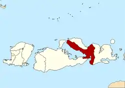 Location within West Nusa Tenggara | |
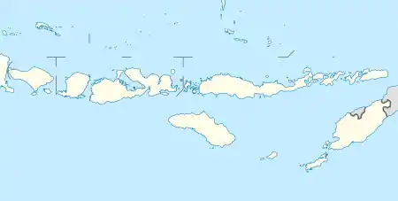 Dompu Regency Location in Lesser Sunda Islands and Indonesia  Dompu Regency Dompu Regency (Indonesia) | |
| Coordinates: 8°32′S 118°28′E | |
| Country | |
| Province | |
| Capital | Dompu |
| Government | |
| • Regent | Kader Jaelani |
| • Vice Regent | Syahrul Parsan |
| Area | |
| • Total | 2,324.55 km2 (897.51 sq mi) |
| Population (mid 2023 estimate)[1] | |
| • Total | 239,781 |
| • Density | 100/km2 (270/sq mi) |
| Time zone | UTC+8 (ICST) |
| Area code | (+62) 373 |
| Website | dompukab |
Administrative Districts
Dompu Regency consists of eight districts (kecamatan), tabulated below with their areas and their populations at the 2010 Census[2] and the 2020 Census,[3] together with the official estimates as at mid 2023.[1] The table also includes the locations of the district administrative centres, the number of administrative villages (totaling 72 rural desa and 9 urban kelurahan) and the number of offshore islands in each district, and its postal codes.
| Kode Wilayah | Name of District (kecamatan) | Area in km2 | Pop'n 2010 Census | Pop'n 2020 Census | Pop'n mid 2023 Estimate | Admin centre | No. of villages | No. of islands | Post code |
|---|---|---|---|---|---|---|---|---|---|
| 52.05.03 | Hu'u | 186.50 | 16,050 | 17,864 | 18,790 | Rasabou | 8 | - | 84271 |
| 52.05.08 | Pajo | 135.32 | 12,545 | 13,689 | 14,320 | Ranggo | 6 | 1 | 84272 |
| 52.05.01 | Dompu (district) | 223.27 | 49,854 | 54,987 | 57,680 | Bada | 15 (a) | - | 84211 -84219 |
| 52.05.05 | Woja | 301.16 | 51,704 | 57,019 | 59,810 | Montabaru | 14 (b) | 1 | 84251 (c) |
| 52.05.04 | Kilo | 235.00 | 11,971 | 13,003 | 13,580 | Malaju | 6 | - | 84252 |
| 52.05.02 | Kempo | 191.67 | 18,185 | 18,962 | 19,560 | Kempo | 8 | 3 | 84261 |
| 52.05.07 | Manggelewa | 176.46 | 27,777 | 30,231 | 31,590 | Soriutu | 12 | 17 | 84253 |
| 52.05.06 | Pekat (d) | 875.17 | 30,887 | 30,910 | 31,860 | Pekat | 12 | 1 | 84260 |
| Totals | 2,324.55 | 218,973 | 236,665 | 247,188 | Dompu | 81 | 23 |
Notes: (a) includes 6 kelurahan. (b) includes 3 kelurahan. (c) except the villages of Kandai II (with a post code of 84218) and Monta Baru (with a post code of 84219).
(d) comprises the southern half of the Sanggar Peninsula, plus the small island of Satonda off the north coast of that peninsula.
References
- Badan Pusat Statistik, Jakarta, 28 February 2024, Kabupaten Dompu Dalam Angka 2024 (Katalog-BPS 1102001.5205)
- Biro Pusat Statistik, Jakarta, 2011.
- Badan Pusat Statistik, Jakarta, 2021.
External links
- Official website
- Hägerdal, Hans (2017), Held's History of Sumbawa. Amsterdam: Amsterdam University Press. Archived 2019-12-22 at the Wayback Machine
Regencies and cities of West Nusa Tenggara | ||
|---|---|---|
Capital: Mataram | ||
| Regencies |
| |
| Cities | ||