Sumbawa Regency
Sumbawa Regency (Indonesian: Kabupaten Sumbawa) is a Regency (Kabupaten) of the Indonesian Province of West Nusa Tenggara. It is located on the island of Sumbawa and covers an area of 6,643.99 km2, following the separation on 18 December 2003 of what were until then its westernmost five districts to form the newly-created West Sumbawa Regency. It includes the substantial island of Moyo, lying off the north coast of Sumbawa. The population of the Regency at the 2010 Census was 415,789,[2] which rose at the 2020 Census to 509,753;[3] the official estimate as at mid 2023 was 529,487 (comprising 263,272 males and 266,215 females).[1] The capital is the town of Sumbawa Besar on the north coast of Sumbawa Island.
Sumbawa Regency
Kabupaten Sumbawa | |
|---|---|
 Coat of arms | |
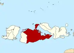 Location within West Nusa Tenggara | |
 Sumbawa Regency Location in Lesser Sunda Islands and Indonesia  Sumbawa Regency Sumbawa Regency (Indonesia) | |
| Coordinates: 8.744808°S 117.671525°E | |
| Country | |
| Province | |
| Capital | Sumbawa Besar |
| Government | |
| • Regent | Mahmud Abdullah |
| • Vice Regent | Dewi Noviani |
| Area | |
| • Total | 6,643.99 km2 (2,565.26 sq mi) |
| Population (mid 2023 estimate) | |
| • Total | 529,487 |
| • Density | 80/km2 (210/sq mi) |
| [1] | |
| Time zone | UTC+8 (ICST) |
| Area code | (+62) 371 |
| Website | sumbawakab.go.id |
Administrative districts
Sumbawa Regency is divided into twenty-four administrative districts (kecamatan), listed below with their areas and their populations at the 2010 Census[2] and the 2020 Census,[3] together with the official estimates as at mid 2023.[1] The table also includes the locations of the district administrative centres, the number of administrative villages in each district (totaling 157 rural desa and 8 urban kelurahan, the latter all in Sumbawa town District), and its postal code(s).
| Kode Wilayah | Name of District (kecamatan) | Area in km2 | Pop'n 2010 Census | Pop'n 2020 Census | Pop'n mid 2023 Estimate | Admin centre | No. of villages | Post code |
|---|---|---|---|---|---|---|---|---|
| 52.04.02 | Lunyuk | 513.74 | 18,109 | 22,118 | 22,939 | Lunyuk Ode | 7 | 84373 |
| 52.04.28 | Orong Telu | 465.97 | 4,584 | 5,478 | 5,645 | Kelawis | 4 | 84374 |
| 52.04.05 | Alas | 123.04 | 28,121 | 33,281 | 34,201 | Dalam | 8 | 84353 |
| 52.04.17 | Alas Barat (Alas West) (a) | 168.88 | 18,382 | 25,137 | 26,939 | Usar Mapin | 8 | 84354 |
| 52.04.20 | Buer (b) | 137.01 | 13,621 | 16,966 | 17,696 | Labuhan Burung | 6 | 84355 |
| 52.04.06 | Utan | 155.42 | 28,745 | 35,799 | 37,338 | Jorok | 9 | 84351 |
| 52.04.21 | Rhee | 230.82 | 6,899 | 9,091 | 9,638 | Rhee | 4 | 84352 |
| 52.04.07 | Batu Lanteh | 391.40 | 10,156 | 11,824 | 12,093 | Kelungkung | 6 | 84361 |
| 52.04.08 | Sumbawa (town) (Sumbawa Besar) | 44.83 | 56,337 | 62,753 | 63,362 | Sumbawa | 8 (c) | 84311 -84318 |
| 52.04.18 | Labuhan Badas (d) | 435.89 | 29,092 | 35,427 | 36,710 | Karang Dima | 7 | 84316 |
| 52.04.22 | Unter Iwes | 82.38 | 18,150 | 23,366 | 24,606 | Kerato | 8 | 84310 |
| 52.04.09 | Moyo Hilir (Lower Moyo) | 186.79 | 22,099 | 27,961 | 29,297 | Moyo | 10 | 84381 |
| 52.04.23 | Moyo Utara (North Moyo) | 90.80 | 9,129 | 11,509 | 12,046 | Sebewe | 6 | 84380 |
| 52.04.10 | Moyo Hulu (Upper Moyo) | 311.96 | 19,911 | 24,637 | 25,648 | Semamung | 12 | 84371 |
| 52.04.11 | Ropang | 444.48 | 5,014 | 6,141 | 6,374 | Ropang | 5 | 84375 |
| 52.04.27 | Lenangguar | 504.32 | 6,320 | 7,912 | 8,265 | Lenangguar | 4 | 84370 |
| 52.04.29 | Lantung | 167.45 | 2,768 | 3,879 | 4,187 | Lantung | 4 | 84372 |
| 52.04.12 | Lape | 204.43 | 16,120 | 19,928 | 20,740 | Dete | 4 | 84382 |
| 52.04.26 | Lopok | 155.59 | 17,564 | 21,422 | 22,208 | Langam | 7 | 84388 |
| 52.04.13 | Plampang | 418.69 | 27,834 | 34,453 | 35,870 | Plampang | 11 | 84386 |
| 52.03.19 | Labangka | 243.08 | 10,212 | 13,283 | 14,030 | Suka Damai | 5 | 84383 |
| 52.04.24 | Maronge | 274.75 | 9,771 | 12,007 | 12,474 | Maronge | 4 | 84387 |
| 52.04.14 | Empang | 558.55 | 21,655 | 26,220 | 27,124 | Empang Bawa | 10 | 84384 |
| 52.04.25 | Tarano | 333.71 | 15,196 | 19,161 | 20,057 | Labuhan Bontong | 8 | 84385 |
| Totals | 6,643.99 | 415,789 | 509,753 | 529,487 | Sumbawa Besar | 165 |
Note: (a) including Panjang Island off the northwest coast of Sumbawa. (b) including Saringi Island and 4 smaller islands off the northwest coast of Sumbawa.
(c) The 8 villages comprising Sumbawa (town) District are classed as urban kelurahan; the other 157 villages in the regency are all classed as rural desa.
(d) Labuhan Badas District comprises the substantial island of Pulau Moyo (administratively, Labuhan Aji and Sebotok desa), the smaller Pulau Medang (with even smaller Bajo Medang) to its west, and the small Pulau Sakonci to its northeast off the coast of the Sanggar Peninsula, together with a substantial area on mainland Sumbawa situated to the west of Sumbawa Besar (town) and containing most of the district's population. Note that the three districts with "Moyo" in their names do not include any part of Moyo Island, but are situated to its south on Sumbawa Island itself and on other offshore islands.
Sister Districts
![]() Kulim, Malaysia
Kulim, Malaysia
References
- Badan Pusat Statistik, Jakarta, 28 February 2024, Kabupaten Sumbawa Dalam Angka 2024 (Katalog-BPS 1102001.5204)
- Biro Pusat Statistik, Jakarta, 2011.
- Badan Pusat Statistik, Jakarta, 2021.
External links
Regencies and cities of West Nusa Tenggara | ||
|---|---|---|
Capital: Mataram | ||
| Regencies |
| |
| Cities | ||