Bagneux, Meurthe-et-Moselle
Bagneux (French pronunciation: [baɲø] ⓘ) is a commune in the Meurthe-et-Moselle department in northeastern France.
Bagneux | |
|---|---|
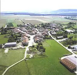 An aerial view of Bagneux | |
 Coat of arms | |
Location of Bagneux | |
 Bagneux 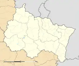 Bagneux | |
| Coordinates: 48°33′32″N 5°53′00″E | |
| Country | France |
| Region | Grand Est |
| Department | Meurthe-et-Moselle |
| Arrondissement | Toul |
| Canton | Meine au Saintois |
| Intercommunality | CC Pays de Colombey et Sud Toulois |
| Government | |
| • Mayor (2020–2026) | Ludovic Deloche[1] |
| Area 1 | 8.6 km2 (3.3 sq mi) |
| Population (2021)[2] | 135 |
| • Density | 16/km2 (41/sq mi) |
| Time zone | UTC+01:00 (CET) |
| • Summer (DST) | UTC+02:00 (CEST) |
| INSEE/Postal code | 54041 /54170 |
| Elevation | 243–306 m (797–1,004 ft) (avg. 270 m or 890 ft) |
| 1 French Land Register data, which excludes lakes, ponds, glaciers > 1 km2 (0.386 sq mi or 247 acres) and river estuaries. | |
Population
| Year | Pop. | ±% p.a. |
|---|---|---|
| 1968 | 137 | — |
| 1975 | 135 | −0.21% |
| 1982 | 142 | +0.72% |
| 1990 | 131 | −1.00% |
| 1999 | 132 | +0.08% |
| 2009 | 150 | +1.29% |
| 2014 | 157 | +0.92% |
| 2020 | 138 | −2.13% |
| Source: INSEE[3] | ||
References
- "Répertoire national des élus: les maires". data.gouv.fr, Plateforme ouverte des données publiques françaises (in French). 9 August 2021.
- "Populations légales 2021". The National Institute of Statistics and Economic Studies. 28 December 2023.
- Population en historique depuis 1968, INSEE
Wikimedia Commons has media related to Bagneux (Meurthe-et-Moselle).
This article is issued from Wikipedia. The text is licensed under Creative Commons - Attribution - Sharealike. Additional terms may apply for the media files.