Bow Range
The Bow Range is a mountain range of the Canadian Rockies in Alberta and British Columbia, Canada. The range is named in association with the Bow River and was officially adopted on March 31, 1917 by the Geographic Board of Canada.[4]
| Bow Range | |
|---|---|
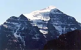 North face of Mount Temple | |
| Highest point | |
| Peak | Mount Temple, Alberta |
| Elevation | 3,543 m (11,624 ft)[1] |
| Listing | Mountains of Alberta |
| Coordinates | 51°21′02″N 116°12′24″W[2] |
| Dimensions | |
| Length | 34 km (21 mi) N-S[3] |
| Width | 43 km (27 mi)[3] |
| Area | 717 km2 (277 sq mi)[3] |
| Geography | |
 Bow Range | |
| Country | Canada |
| Provinces | Alberta and British Columbia |
| Protected areas | |
| Range coordinates | 51°20′00″N 116°17′00″W[4] |
| Parent range | Canadian Rockies (Southern Continental Ranges) |
| Borders on | Waputik Range, Slate Range, Ball Range and Ottertail Range |
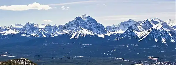
It is a part of the Banff-Lake Louise Core Area of the Southern Continental Ranges, located on the Continental Divide, west of the Bow River valley, in Banff National Park and Kootenay National Park.
The Bow Range covers a surface area of 717 km2 (277 sq mi), has a length of 34 km (from north to south) and a maximum width of 43 km.[3] The highest peak is Mount Temple, with an elevation of 3,543 m (11,624 ft).[1] The range also covers the Valley of the Ten Peaks, with the tallest of the ten being Mount Hungabee at 3492 metres. The range also has hiking areas such as the Consolation Lakes, Sentinel Pass-Larch Valley, Wenkchenma Pass-Eiffel Lake, the Beehive plain of the Six Glaciers system and Saddle Back Pass.
Peaks and mountains
| Name | Elevation | Prominence | FA | Easiest route | Coordinates | ||
|---|---|---|---|---|---|---|---|
| m | ft | m | ft | ||||
| Mount Temple | 11,624
style="text-align:right;" data-sort-value="7003154400000000000"|1,544 |
5,066 | 1894 | Moderate scramble on SW face | 51°21′2″N 116°12′25″W | ||
| Hungabee Mountain | 11,457
style="text-align:right;" data-sort-value="7002987000000000000"|987 |
3,238 | 1903 | UIAA III 5.4 on West ridge | 51°19′58″N 116°17′2″W | ||
| Mount Victoria | 11,365
style="text-align:right;" data-sort-value="7002547000000000000"|547 |
1,795 | 1897 | UIAA II on SE ridge, South Summit | 51°22′37″N 116°18′24″W | ||
| Deltaform Mountain | 11,234
style="text-align:right;" data-sort-value="7002822000000000000"|822 |
2,697 | 1903 | UIAA II 5.5 on NW ridge | 51°18′6″N 116°14′43″W | ||
| Mount Lefroy | 11,230
style="text-align:right;" data-sort-value="7002417000000000000"|417 |
1,368 | 1897 | UIAA II on West face | 51°21′44″N 116°16′47″W | ||
| Mount Huber | 11,050
style="text-align:right;" data-sort-value="7002168000000000000"|168 |
551 | 1903 | 51°22′13″N 116°18′44″W | |||
| Mount Biddle | 10,890
style="text-align:right;" data-sort-value="7002731000000000000"|731 |
2,398 | 1902 | 51°19′24″N 116°18′26″W | |||
| Mount Tuzo | 10,650
style="text-align:right;" data-sort-value="7002210000000000000"|210 |
690 | 1906 | 51°18′6″N 116°13′42″W | |||
| Mount Fay | 10,614
style="text-align:right;" data-sort-value="7002389000000000000"|389 |
1,276 | 1904 | 51°17′58″N 116°9′43″W | |||
| Neptuak Mountain | 10,607
style="text-align:right;" data-sort-value="7002151000000000000"|151 |
495 | 1902 | 51°18′28″N 116°15′29″W | |||
| Quadra Mountain | 10,410
style="text-align:right;" data-sort-value="7002285000000000000"|285 |
935 | 1910 | 51°17′13″N 116°9′12″W | |||
| Mount Aberdeen | 10,341
style="text-align:right;" data-sort-value="7002566000000000000"|566 |
1,857 | 1894 | 51°22′48″N 116°14′51″W | |||
| Odaray Mountain | 10,292
style="text-align:right;" data-sort-value="7002627000000000000"|627 |
2,057 | 1887 | 51°21′37″N 116°23′3″W | |||
| Mount Babel | 10,174
style="text-align:right;" data-sort-value="7002200000000000000"|200 |
660 | 1910 | UIAA IV 5.10 A1 on East face | 51°18′23″N 116°9′48″W | ||
| Mount Little | 10,131
style="text-align:right;" data-sort-value="7002164000000000000"|164 |
538 | 1901 | 51°17′45″N 116°10′58″W | |||
| Bident Mountain | 10,118
style="text-align:right;" data-sort-value="7002103000000000000"|103 |
338 | 1903 | 51°17′15″N 116°8′28″W | |||
| Mount Owen | 10,115
style="text-align:right;" data-sort-value="7002903000000000000"|903 |
2,963 | 1892 | 51°18′58″N 116°25′13″W | |||
| Eiffel Peak | 10,095
style="text-align:right;" data-sort-value="7002465000000000000"|465 |
1,526 | 1901 | Scramble | 51°19′56″N 116°14′7″W | ||
| Haddo Peak | 10,070
style="text-align:right;" data-sort-value="7001830000000000000"|83 |
272 | 1903 | 51°23′0″N 116°14′12″W | |||
| Pinnacle Mountain | 10,070
style="text-align:right;" data-sort-value="7002225000000000000"|225 |
738 | 1909 | 51°20′20″N 116°13′39″W | |||
| Mount Perren | 10,010
style="text-align:right;" data-sort-value="7002113000000000000"|113 |
371 | 1927 | 51°17′47″N 116°12′32″W | |||
| Chimney Peak | 9,849
style="text-align:right;" data-sort-value="7002137000000000000"|137 |
449 | 1910 | 51°15′52″N 116°9′19″W | |||
| Mount Whyte | 9,787
style="text-align:right;" data-sort-value="7002140000000000000"|140 |
460 | 1901 | Difficult scramble or Perren Route II 5.6 | 51°24′31″N 116°16′16″W | ||
| Mount Niblock | 9,764
style="text-align:right;" data-sort-value="7002142000000000000"|142 |
466 | 1899 | Moderate scramble | 51°25′3″N 116°16′16″W | ||
| Mount Bell | 9,619
style="text-align:right;" data-sort-value="7002225000000000000"|225 |
738 | 1910 | Moderate scramble | 51°17′3″N 116°6′4″W | ||
| Fairview Mountain | 9,003
style="text-align:right;" data-sort-value="7002275000000000000"|275 |
902 | 1893 | Easy scramble above Lake Louise | 51°23′58″N 116°13′24″W | ||
| Mount St. Piran | 8,691
style="text-align:right;" data-sort-value="7002187000000000000"|187 |
614 | Hiking trail | 51°25′17″N 116°15′10″W | |||
| Saddle Mountain | 7,982
style="text-align:right;" data-sort-value="7002107000000000000"|107 |
351 | Hiking trail | 51°23′35″N 116°12′31″W | |||
| Big Beehive | 2,270 | 7,450 | Hiking trail | 51°24′51″N 116°14′38″W | |||
References
- "Mount Temple". cdnrockiesdatabases.ca. Retrieved 2019-08-17.
- "Mount Temple". Geographical Names Data Base. Natural Resources Canada. Retrieved 2023-09-04.
- "Bow Range". Peakbagger.com. Retrieved 2006-09-20.
- "Bow Range". BC Geographical Names. Retrieved 2009-01-13.