Mount Saskatchewan (Alberta)
Mount Saskatchewan is a mountain located in the North Saskatchewan River valley of Banff National Park, in the Canadian Rockies of Alberta, Canada.
| Mount Saskatchewan | |
|---|---|
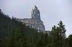
.jpg.webp) Mt. Saskatchewan | |
| Highest point | |
| Elevation | 3,342 m (10,965 ft)[1][2] |
| Prominence | 1,102 m (3,615 ft)[3] |
| Parent peak | Mount Andromeda (3450 m)[3] |
| Listing | Mountains of Alberta |
| Coordinates | 52°05′59″N 117°05′36″W[4] |
| Geography | |
 Mount Saskatchewan | |
| Country | Canada |
| Province | Alberta |
| Protected area | Banff National Park |
| Parent range | Columbia Icefield |
| Topo map | NTS 83C3 Columbia Icefield[4] |
| Climbing | |
| First ascent | July 12, 1923, by Conrad Kain, W.S. Ladd, J. Monroe Thorington[5][6] |
| Easiest route | technical climb |
J. Norman Collie named the mountain in 1898 for the nearby Saskatchewan River.[3] One report said Collie so named it due to its possession of the headwaters of the North Saskatchewan River.[7]
Lighthouse Tower
A 75 m (246 ft) pinnacle unofficially named Lighthouse Tower and also sometimes referred to as "Cleopatra's Needle" (elevation 2,960 m (9,710 ft)),[2] is located two kilometres from the summit on the eastern ridge of Mt. Saskatchewan.[1]
It was first climbed in 1964 by G. Boehnisch and L. Mackay.[8]
Geology
Like other mountains in Banff Park, Mount Saskatchewan is composed of sedimentary rock laid down from the Precambrian to Jurassic periods.[9] Formed in shallow seas, this sedimentary rock was pushed east and over the top of younger rock during the Laramide orogeny.[10] The north aspect of the peak supports an unnamed glacier which can be seen well from Parker Ridge.

Climate
Based on the Köppen climate classification, Mount Saskatchewan is located in a subarctic climate with cold, snowy winters, and mild summers.[11] Temperatures can drop below −20 °C with wind chill factors below −30 °C. Weather conditions during summer months are optimum for climbing.
See also
- List of mountains of Canada
- List of mountains in the Canadian Rockies
References
- "Mount Saskatchewan". cdnrockiesdatabases.ca. Retrieved 2019-08-16.
- "Topographic map of Mount Saskatchewan". opentopomap.org. Retrieved 2021-11-07.
- "Mount Saskatchewan". Bivouac.com. Retrieved 2009-01-02.
- "Mount Saskatchewan". Geographical Names Data Base. Natural Resources Canada. Retrieved 2017-08-06.
- Thorington, J. Monroe (2012). "Chapter VI: Mount Saskatchewan and Mount Columbia". The Glittering Mountains of Canada. Calgary: Rocky Mountain Books. Kindle Edition. ISBN 978-1927330067.
- Thorington, J. Monroe (1966) [1921]. "Thompson Pass to Head of Athabaska River". A Climber's Guide to the Rocky Mountains of Canada. With the collaboration of Putnam, William Lowell (6th ed.). American Alpine Club. pp. 230–231. ISBN 978-1376169003.
- Geographic Board of Canada. Place Names of Alberta (1928)
- "Lighthouse Tower". cdnrockiesdatabases.ca. Retrieved 2019-08-16.
- Belyea, Helen R. (1960). The Story of the Mountains in Banff National Park (PDF). parkscanadahistory.com (Report). Ottawa: Geological Survey of Canada. Archived (PDF) from the original on 2015-10-02. Retrieved 2019-09-13.
- Gadd, Ben (2008). Geology of the Rocky Mountains and Columbias.
- Peel, M. C.; Finlayson, B. L.; McMahon, T. A. (2007). "Updated world map of the Köppen−Geiger climate classification". Hydrol. Earth Syst. Sci. 11: 1633–1644. ISSN 1027-5606.
External links
- Parks Canada web site: Banff National Park
- Mount Saskatchewan weather: Mountain Forecast