Winston Churchill Range
The Winston Churchill Range is a mountain range in the central section of the Park Ranges of the Canadian Rockies located in Jasper National Park.[5] The range was named after Sir Winston Churchill, former British prime minister.
| Winston Churchill Range | |
|---|---|
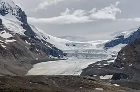 Athabasca Glacier in the Winston Churchill Range | |
| Highest point | |
| Peak | Mount Columbia |
| Elevation | 3,747 m (12,293 ft)[1] |
| Listing | Mountains of Alberta |
| Coordinates | 52°08′51″N 117°26′26″W[2] |
| Dimensions | |
| Length | 31 km (19 mi) N/S[3] |
| Width | 23 km (14 mi) E/W[3] |
| Area | 410 km2 (160 sq mi)[3] |
| Naming | |
| Etymology | Winston Churchill |
| Geography | |
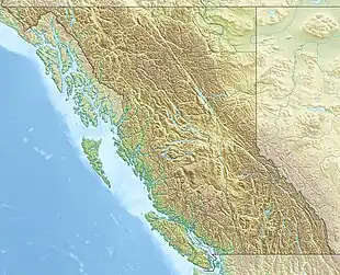 Winston Churchill Range Location in British Columbia  Winston Churchill Range Location in Alberta | |
| Country | Canada |
| Provinces | British Columbia and Alberta |
| Protected area | Jasper National Park |
| Range coordinates | 52°21′32″N 117°26′58″W[4] |
| Parent range | Park Ranges |
| Topo map | NTS 83C6 Sunwapta Peak |
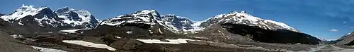
Mount Athabasca, Mount Andromeda, Athabasca Glacier, Snow Dome, Dome Glacier and Mount Kitchener
The eastern boundary of the range begins on the western side of Sunwapta River from the Jasper and Banff boundary and extends north to Sunwapta Falls. The western boundary of the range is defined by the Athabasca River valley to the east of Warwick Mountain. The valley narrows as it approaches the Continental Divide, and separates Mt. Columbia from Mt. King Edward, the latter of which is not part of the range.
List of mountains
This range includes the following mountains and peaks:
| Mountain/Peak | Elevation | Coordinates | |
|---|---|---|---|
| m | ft | ||
| Mount Columbia | 3,747 | 12,293 | 52°8′51″N 117°26′26″W |
| North Twin Peak | 3,684 | 12,087 | 52°13′25″N 117°26′3″W |
| Twins Tower | 3,627 | 11,900 | 52°21'32"N, 117°26'58"W |
| Mount Alberta | 3,619 | 11,873 | 52°17′14″N 117°28′37″W |
| South Twin Peak | 3,566 | 11,699 | 52°12′14″N 117°26′5″W |
| Mount Kitchener | 3,505 | 11,499 | 52°13′3″N 117°19′12″W |
| Snow Dome | 3,456 | 11,339 | 52°11′13″N 117°19′1″W |
| Stutfield Peak | 3,450 | 11,320 | 52°14′18″N 117°24′27″W |
| Mount Woolley | 3,405 | 11,171 | 52°17′50″N 117°25′31″W |
| Diadem Peak | 3,371 | 11,060 | 52°18′38″N 117°25′15″W |
| Mount Cromwell | 3,330 | 10,930 | 52°16′10″N 117°23′31″W |
| Mount Engelhard | 3,270 | 10,730 | 52°16′30″N 117°24′22″W |
| Mount Smythe | 3,246 | 10,650 | 52°21′20″N 117°28′30″W |
| Mushroom Peak | 3,210 | 10,530 | 52°18′43″N 117°23′49″W |
| Thorington Tower | 3,155 | 10,351 | 52°21′27″N 117°30′11″W |
| Mount Nelson | 3,150 | 10,330 | 52°20′46″N 117°28′8″W |
| Mount Palmer | 3,150 | 10,330 | 52°21′10″N 117°31′14″W |
| Mount GEC | 3,130 | 10,270 | 52°20′11″N 117°27′0″W |
| Gong Peak | 3,120 | 10,240 | 52°22′11″N 117°27′32″W |
| Mount Adam Joachim | 3,094 | 10,151 | 52°24′16″N 117°31′41″W |
| Mount K2 | 3,090 | 10,140 | 52°13′30″N 117°17′31″W |
| Mount Weiss | 3,090 | 10,140 | 52°23′28″N 117°28′30″W |
| Mount Mitchell | 3,040 | 9,970 | 52°24′12″N 117°30′14″W |
| Mount Morden Long | 3,040 | 9,970 | 52°25′21″N 117°32′17″W |
| Mount McGuire | 3,030 | 9,940 | 52°22′28″N 117°27′7″W |
| Mount Confederation | 2,969 | 9,741 | 52°24′13″N 117°34′34″W |
| Little Alberta | 2,956 | 9,698 | 52°16′26″N 117°26′17″W |
References
- "Topographic map of Mount Columbia". opentopomap.org. Retrieved 2023-07-15.
- "Mount Columbia". Geographical Names Data Base. Natural Resources Canada. Retrieved 2023-07-15.
- "Winston Churchill Range". Peakbagger.com. Retrieved 2013-05-17.
- "Winston Churchill Range". Geographical Names Data Base. Natural Resources Canada. Retrieved 2013-05-17.
- Ommanney, C. Simon (2002). "Glaciers of the Canadian Rockies". USGS Professional Paper 1386-J-1. Satellite image atlas of glaciers of the world -- North America: J201, J230, J260. doi:10.3133/pp1386J.
This article is issued from Wikipedia. The text is licensed under Creative Commons - Attribution - Sharealike. Additional terms may apply for the media files.