Pike County, Georgia
Pike County is a county located in the west central portion of the U.S. state of Georgia. As of the 2020 census, the population was 18,889.[1] The county seat is Zebulon.[2]
Pike County | |
|---|---|
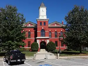 Pike County Courthouse (built 1895), Zebulon | |
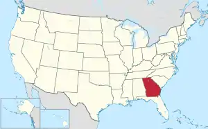
 Location within the U.S. state of Georgia | |
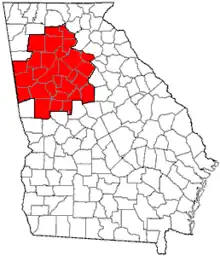
 Georgia's location within the U.S. | |
| Coordinates: 33°05′N 84°23′W | |
| Country | |
| State | |
| Founded | 1822 |
| Named for | Zebulon Pike |
| Seat | Zebulon |
| Largest city | Zebulon |
| Area | |
| • Total | 219 sq mi (570 km2) |
| • Land | 216 sq mi (560 km2) |
| • Water | 3.3 sq mi (9 km2) |
| Population (2020) | |
| • Total | 18,889 |
| • Density | 87/sq mi (34/km2) |
| Time zone | UTC−5 (Eastern) |
| • Summer (DST) | UTC−4 (EDT) |
| Congressional district | 3rd |
| Website | www |
History
Pike County was made from part of Monroe County in 1822. It was named after Zebulon Montgomery Pike, an explorer and army officer.[3]
Geography
According to the U.S. Census Bureau, the county has a total area of 219 square miles (570 km2), of which 216 square miles (560 km2) is land and 3.3 square miles (8.5 km2) (1.5%) is water.[4] The entirety of Pike County is located in the Upper Flint River sub-basin of the ACF River Basin (Apalachicola-Chattahoochee-Flint River Basin).[5] The county is located in the Piedmont region of the state.
Major highways
 U.S. Route 19
 U.S. Route 41
 State Route 3
 State Route 7
 State Route 18
 State Route 74
 State Route 109
 State Route 362
Adjacent counties
- Spalding County (north)
- Lamar County (east)
- Upson County (south)
- Meriwether County (west)
Communities
Cities
- Concord
- Meansville
- Molena
- Williamson
- Zebulon (county seat)
Census-designated place
- Hilltop
Unincorporated communities
- Jolly
- Lifsey
Demographics
| Census | Pop. | Note | %± |
|---|---|---|---|
| 1830 | 6,149 | — | |
| 1840 | 9,176 | 49.2% | |
| 1850 | 14,306 | 55.9% | |
| 1860 | 10,078 | −29.6% | |
| 1870 | 10,905 | 8.2% | |
| 1880 | 15,849 | 45.3% | |
| 1890 | 16,300 | 2.8% | |
| 1900 | 18,761 | 15.1% | |
| 1910 | 19,495 | 3.9% | |
| 1920 | 21,212 | 8.8% | |
| 1930 | 10,853 | −48.8% | |
| 1940 | 10,375 | −4.4% | |
| 1950 | 8,459 | −18.5% | |
| 1960 | 7,138 | −15.6% | |
| 1970 | 7,316 | 2.5% | |
| 1980 | 8,937 | 22.2% | |
| 1990 | 10,224 | 14.4% | |
| 2000 | 13,688 | 33.9% | |
| 2010 | 17,869 | 30.5% | |
| 2020 | 18,889 | 5.7% | |
| 2023 (est.) | 20,461 | [6] | 8.3% |
| U.S. Decennial Census[7] 1790-1880[8] 1890-1910[9] 1920-1930[10] 1930-1940[11] 1940-1950[12] 1960-1980[13] 1980-2000[14] 2010[15] | |||
| Race | Num. | Perc. |
|---|---|---|
| White (non-Hispanic) | 16,313 | 86.36% |
| Black or African American (non-Hispanic) | 1,445 | 7.65% |
| Native American | 28 | 0.15% |
| Asian | 77 | 0.41% |
| Other/Mixed | 678 | 3.59% |
| Hispanic or Latino | 348 | 1.84% |
As of the 2020 United States census, there were 18,889 people, 6,143 households, and 4,525 families residing in the county.
Education
Georgia Military College has an extension campus near Zebulon City Hall.
The Pike County School District serves Pike County. The school district has one Pre-K building (lottery funded), one primary school (K-2), one elementary school (3-5), one middle school (6-8), a ninth grade academy and one high school (10-12). Michael Duncan, Ed.D. is the Superintendent of Schools.[17]
Politics
| Year | Republican | Democratic | Third party | |||
|---|---|---|---|---|---|---|
| No. | % | No. | % | No. | % | |
| 2020 | 9,127 | 85.13% | 1,505 | 14.04% | 89 | 0.83% |
| 2016 | 7,278 | 83.03% | 1,240 | 14.15% | 248 | 2.83% |
| 2012 | 6,668 | 81.93% | 1,356 | 16.66% | 115 | 1.41% |
| 2008 | 6,547 | 79.64% | 1,575 | 19.16% | 99 | 1.20% |
| 2004 | 5,193 | 76.94% | 1,506 | 22.31% | 50 | 0.74% |
| 2000 | 3,358 | 68.74% | 1,413 | 28.93% | 114 | 2.33% |
| 1996 | 2,054 | 52.52% | 1,474 | 37.69% | 383 | 9.79% |
| 1992 | 1,822 | 44.40% | 1,651 | 40.23% | 631 | 15.38% |
| 1988 | 2,074 | 63.35% | 1,176 | 35.92% | 24 | 0.73% |
| 1984 | 1,855 | 60.66% | 1,203 | 39.34% | 0 | 0.00% |
| 1980 | 1,271 | 41.08% | 1,755 | 56.72% | 68 | 2.20% |
| 1976 | 776 | 28.97% | 1,903 | 71.03% | 0 | 0.00% |
| 1972 | 1,432 | 77.20% | 423 | 22.80% | 0 | 0.00% |
| 1968 | 345 | 14.26% | 632 | 26.13% | 1,442 | 59.61% |
| 1964 | 1,064 | 52.94% | 946 | 47.06% | 0 | 0.00% |
| 1960 | 255 | 19.88% | 1,028 | 80.12% | 0 | 0.00% |
| 1956 | 210 | 16.44% | 1,067 | 83.56% | 0 | 0.00% |
| 1952 | 286 | 18.64% | 1,248 | 81.36% | 0 | 0.00% |
| 1948 | 72 | 15.25% | 256 | 54.24% | 144 | 30.51% |
| 1944 | 133 | 15.20% | 742 | 84.80% | 0 | 0.00% |
| 1940 | 209 | 20.13% | 829 | 79.87% | 0 | 0.00% |
| 1936 | 149 | 14.03% | 910 | 85.69% | 3 | 0.28% |
| 1932 | 33 | 3.10% | 1,021 | 95.96% | 10 | 0.94% |
| 1928 | 238 | 25.00% | 714 | 75.00% | 0 | 0.00% |
| 1924 | 41 | 4.07% | 895 | 88.79% | 72 | 7.14% |
| 1920 | 280 | 17.98% | 1,277 | 82.02% | 0 | 0.00% |
| 1916 | 65 | 6.94% | 766 | 81.75% | 106 | 11.31% |
| 1912 | 34 | 3.70% | 753 | 81.85% | 133 | 14.46% |
See also
- National Register of Historic Places listings in Pike County, Georgia
- List of counties in Georgia
References
- "Census - Geography Profile: Pike County, Georgia". United States Census Bureau. Retrieved December 28, 2022.
- "Find a County". National Association of Counties. Retrieved June 7, 2011.
- Krakow, Kenneth K. (1975). Georgia Place-Names: Their History and Origins (PDF). Macon, GA: Winship Press. p. 176. ISBN 0-915430-00-2. Archived (PDF) from the original on September 17, 2003.
- "US Gazetteer files: 2010, 2000, and 1990". United States Census Bureau. February 12, 2011. Retrieved April 23, 2011.
- "Georgia Soil and Water Conservation Commission Interactive Mapping Experience". Georgia Soil and Water Conservation Commission. Retrieved November 20, 2015.
- "Annual Estimates of the Resident Population for Counties: April 1, 2020 to July 1, 2023". United States Census Bureau. Retrieved March 31, 2024.
- "Decennial Census of Population and Housing by Decades". United States Census Bureau.
- "1880 Census Population by Counties 1790-1800" (PDF). United States Census Bureau. 1880.
- "1910 Census of Population - Georgia" (PDF). United States Census Bureau. 1910.
- "1930 Census of Population - Georgia" (PDF). United States Census Bureau. 1930.
- "1940 Census of Population - Georgia" (PDF). United States Census Bureau. 1940.
- "1950 Census of Population - Georgia -" (PDF). United States Census Bureau. 1950.
- "1980 Census of Population - Number of Inhabitants - Georgia" (PDF). United States Census Bureau. 1980.
- "2000 Census of Population - Population and Housing Unit Counts - Georgia" (PDF). United States Census Bureau. 2000.
- "State & County QuickFacts". United States Census Bureau. Archived from the original on June 7, 2011. Retrieved February 18, 2014.
- "Explore Census Data". data.census.gov. Retrieved December 13, 2021.
- "Pike County Schools". Pike County Schools. Retrieved June 30, 2012.
- Leip, David. "Dave Leip's Atlas of U.S. Presidential Elections". uselectionatlas.org. Retrieved March 22, 2018.
Places adjacent to Pike County, Georgia | ||||||||||||||||
|---|---|---|---|---|---|---|---|---|---|---|---|---|---|---|---|---|
| ||||||||||||||||
Municipalities and communities of Pike County, Georgia, United States | ||
|---|---|---|
| Cities | Map of Georgia highlighting Pike County | |
| Towns | ||
| CDP |
| |
| Unincorporated communities |
| |
| ||
|  | |||||
|
| ||||||