Châtelus, Allier
Châtelus is a commune in the Allier department in central France.
Châtelus | |
|---|---|
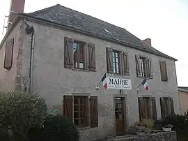 Town hall | |
.svg.png.webp) Coat of arms | |
Location of Châtelus | |
 Châtelus  Châtelus | |
| Coordinates: 46°11′38″N 3°44′05″E | |
| Country | France |
| Region | Auvergne-Rhône-Alpes |
| Department | Allier |
| Arrondissement | Vichy |
| Canton | Lapalisse |
| Intercommunality | CA Vichy Communauté |
| Government | |
| • Mayor (2020–2026) | Philippe Colas[1] |
| Area 1 | 6.64 km2 (2.56 sq mi) |
| Population (2021)[2] | 108 |
| • Density | 16/km2 (42/sq mi) |
| Time zone | UTC+01:00 (CET) |
| • Summer (DST) | UTC+02:00 (CEST) |
| INSEE/Postal code | 03068 /03120 |
| Elevation | 315–505 m (1,033–1,657 ft) (avg. 360 m or 1,180 ft) |
| 1 French Land Register data, which excludes lakes, ponds, glaciers > 1 km2 (0.386 sq mi or 247 acres) and river estuaries. | |
Population
| Year | Pop. | ±% p.a. |
|---|---|---|
| 1968 | 183 | — |
| 1975 | 194 | +0.84% |
| 1982 | 169 | −1.95% |
| 1990 | 140 | −2.33% |
| 1999 | 132 | −0.65% |
| 2009 | 135 | +0.22% |
| 2014 | 119 | −2.49% |
| 2020 | 103 | −2.38% |
| Source: INSEE[3] | ||
See also
References
- "Répertoire national des élus: les maires" (in French). data.gouv.fr, Plateforme ouverte des données publiques françaises. 13 September 2022.
- "Populations légales 2021". The National Institute of Statistics and Economic Studies. 28 December 2023.
- Population en historique depuis 1968, INSEE
Wikimedia Commons has media related to Châtelus, Allier.
This article is issued from Wikipedia. The text is licensed under Creative Commons - Attribution - Sharealike. Additional terms may apply for the media files.