Le Vilhain
Le Vilhain is a commune in the Allier department in Auvergne-Rhône-Alpes in central France.
Le Vilhain | |
|---|---|
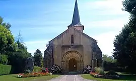 The church in Le Vilhain | |
Location of Le Vilhain | |
 Le Vilhain  Le Vilhain | |
| Coordinates: 46°33′44″N 2°47′53″E | |
| Country | France |
| Region | Auvergne-Rhône-Alpes |
| Department | Allier |
| Arrondissement | Montluçon |
| Canton | Bourbon-l'Archambault |
| Intercommunality | CC du Pays de Tronçais |
| Government | |
| • Mayor (2020–2026) | Kamel Amara[1] |
| Area 1 | 26.37 km2 (10.18 sq mi) |
| Population (2021)[2] | 273 |
| • Density | 10/km2 (27/sq mi) |
| Time zone | UTC+01:00 (CET) |
| • Summer (DST) | UTC+02:00 (CEST) |
| INSEE/Postal code | 03313 /03350 |
| Elevation | 266–412 m (873–1,352 ft) (avg. 360 m or 1,180 ft) |
| 1 French Land Register data, which excludes lakes, ponds, glaciers > 1 km2 (0.386 sq mi or 247 acres) and river estuaries. | |
Population
| Year | Pop. | ±% p.a. |
|---|---|---|
| 1968 | 501 | — |
| 1975 | 361 | −4.57% |
| 1982 | 321 | −1.66% |
| 1990 | 289 | −1.30% |
| 1999 | 267 | −0.88% |
| 2009 | 269 | +0.07% |
| 2014 | 255 | −1.06% |
| 2020 | 276 | +1.33% |
| Source: INSEE[3] | ||
See also
References
- "Répertoire national des élus: les maires" (in French). data.gouv.fr, Plateforme ouverte des données publiques françaises. 13 September 2022.
- "Populations légales 2021". The National Institute of Statistics and Economic Studies. 28 December 2023.
- Population en historique depuis 1968, INSEE
Wikimedia Commons has media related to Le Vilhain.
This article is issued from Wikipedia. The text is licensed under Creative Commons - Attribution - Sharealike. Additional terms may apply for the media files.