Droiturier
Droiturier (French pronunciation: [dʁwatyʁje]; Occitan: Dreturier) is a commune in the Allier department in central France.
Droiturier | |
|---|---|
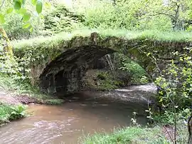 The Romanesque bridge in Droiturier | |
Location of Droiturier | |
 Droiturier  Droiturier | |
| Coordinates: 46°13′53″N 3°43′09″E | |
| Country | France |
| Region | Auvergne-Rhône-Alpes |
| Department | Allier |
| Arrondissement | Vichy |
| Canton | Lapalisse |
| Intercommunality | Pays de Lapalisse |
| Government | |
| • Mayor (2020–2026) | Jérôme Grouly[1] |
| Area 1 | 22.07 km2 (8.52 sq mi) |
| Population (2021)[2] | 365 |
| • Density | 17/km2 (43/sq mi) |
| Time zone | UTC+01:00 (CET) |
| • Summer (DST) | UTC+02:00 (CEST) |
| INSEE/Postal code | 03105 /03120 |
| Elevation | 314–472 m (1,030–1,549 ft) (avg. 450 m or 1,480 ft) |
| 1 French Land Register data, which excludes lakes, ponds, glaciers > 1 km2 (0.386 sq mi or 247 acres) and river estuaries. | |
Population
| Year | Pop. | ±% p.a. |
|---|---|---|
| 1968 | 434 | — |
| 1975 | 392 | −1.44% |
| 1982 | 395 | +0.11% |
| 1990 | 433 | +1.15% |
| 1999 | 385 | −1.30% |
| 2009 | 352 | −0.89% |
| 2014 | 337 | −0.87% |
| 2020 | 360 | +1.11% |
| Source: INSEE[3] | ||
See also
References
- "Répertoire national des élus: les maires" (in French). data.gouv.fr, Plateforme ouverte des données publiques françaises. 13 September 2022.
- "Populations légales 2021". The National Institute of Statistics and Economic Studies. 28 December 2023.
- Population en historique depuis 1968, INSEE
Wikimedia Commons has media related to Droiturier.
This article is issued from Wikipedia. The text is licensed under Creative Commons - Attribution - Sharealike. Additional terms may apply for the media files.