Saint-Didier-la-Forêt
Saint-Didier-la-Forêt (French pronunciation: [sɛ̃ didje la fɔʁɛ]) is a commune in the Allier department in Auvergne-Rhône-Alpes in central France.
Saint-Didier-la-Forêt | |
|---|---|
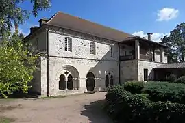 St. Gilbert Abbey | |
 Coat of arms | |
Location of Saint-Didier-la-Forêt | |
 Saint-Didier-la-Forêt  Saint-Didier-la-Forêt | |
| Coordinates: 46°13′34″N 3°20′41″E | |
| Country | France |
| Region | Auvergne-Rhône-Alpes |
| Department | Allier |
| Arrondissement | Vichy |
| Canton | Bellerive-sur-Allier |
| Government | |
| • Mayor (2020–2026) | Martine Deschamps[1] |
| Area 1 | 33.59 km2 (12.97 sq mi) |
| Population (2021)[2] | 376 |
| • Density | 11/km2 (29/sq mi) |
| Time zone | UTC+01:00 (CET) |
| • Summer (DST) | UTC+02:00 (CEST) |
| INSEE/Postal code | 03227 /03110 |
| Elevation | 246–323 m (807–1,060 ft) (avg. 280 m or 920 ft) |
| 1 French Land Register data, which excludes lakes, ponds, glaciers > 1 km2 (0.386 sq mi or 247 acres) and river estuaries. | |
Population
| Year | Pop. | ±% p.a. |
|---|---|---|
| 1968 | 514 | — |
| 1975 | 427 | −2.61% |
| 1982 | 381 | −1.62% |
| 1990 | 375 | −0.20% |
| 1999 | 360 | −0.45% |
| 2009 | 377 | +0.46% |
| 2014 | 386 | +0.47% |
| 2020 | 374 | −0.52% |
| Source: INSEE[3] | ||
See also
References
- "Répertoire national des élus: les maires" (in French). data.gouv.fr, Plateforme ouverte des données publiques françaises. 4 May 2022.
- "Populations légales 2021". The National Institute of Statistics and Economic Studies. 28 December 2023.
- Population en historique depuis 1968, INSEE
Wikimedia Commons has media related to Saint-Didier-la-Forêt.
This article is issued from Wikipedia. The text is licensed under Creative Commons - Attribution - Sharealike. Additional terms may apply for the media files.