Barbour County, Alabama
Barbour County, Alabama is a county of the U.S. state of Alabama. Its name is in honor of James Barbour, who was Governor of Virginia. As of 2000 the population was 29,038. Its county seat is Clayton.
Barbour County | |
|---|---|
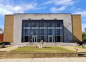
 Barbour County courthouse in Clayton | |
 Location within the U.S. state of Alabama | |
 Alabama's location within the U.S. | |
| Coordinates: 31°51′57″N 85°23′46″W | |
| Country | |
| State | |
| Founded | December 18, 1832 |
| Seat | Clayton |
| Largest city | Eufaula |
| Area | |
| • Total | 905 sq mi (2,340 km2) |
| • Land | 885 sq mi (2,290 km2) |
| • Water | 20 sq mi (50 km2) 2.2%% |
| Population | |
| • Estimate (2017) | 25,270 |
| • Density | 31/sq mi (11.9/km2) |
| Time zone | UTC−6 (Central) |
| • Summer (DST) | UTC−5 (CDT) |
| Congressional district | 2nd |
| |
History
Barbour County was created on December 18, 1832 from former Creek Indian territory and a portion of Pike County. Its borders were altered in 1866 and 1868.[1] The Election Riot of 1874 occurred near Comer.
Major Highways
 U.S. Highway 82
 U.S. Highway 431
 State Route 10
 State Route 30
 State Route 51
Adjacent counties
- Russell County, Alabama - northeast
- Quitman County, Georgia - east
- Stewart County, Georgia - east
- Clay County, Georgia - southeast
- Henry County, Alabama - south
- Dale County, Alabama - south
- Pike County, Alabama - west
- Bullock County, Alabama - northwest
National protected area
- Eufaula National Wildlife Refuge
Cities and towns
- Bakerhill
- Blue Springs
- Clayton
- Clio
- Eufaula
- Elamville
- Louisville
References
- "Alabama Counties: Barbour". Archived from the original on 2008-04-16. Retrieved 2008-06-27.
This article is issued from Wikipedia. The text is licensed under Creative Commons - Attribution - Sharealike. Additional terms may apply for the media files.