Cherokee County, Alabama
Cherokee County, Alabama is a county of the U.S. state of Alabama. It is named for the Cherokee tribe. As of 2010 the population was 25,989. Its county seat is Centre. It is a prohibition or dry county which means alcoholic drinks cannot be sold.
Cherokee County | |
|---|---|
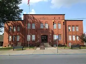 Cherokee County Courthouse in Centre | |
 Location within the U.S. state of Alabama | |
 Alabama's location within the U.S. | |
| Coordinates: 34°10′11″N 85°35′39″W | |
| Country | |
| State | |
| Founded | January 9, 1836 |
| Named for | Cherokee Nation |
| Seat | Centre |
| Largest city | Centre |
| Area | |
| • Total | 600 sq mi (2,000 km2) |
| • Land | 554 sq mi (1,430 km2) |
| • Water | 46 sq mi (120 km2) 7.7%% |
| Population | |
| • Estimate (2017) | 25,857 |
| • Density | 47/sq mi (18/km2) |
| Time zone | UTC−6 (Central) |
| • Summer (DST) | UTC−5 (CDT) |
| Congressional districts | 3rd, 4th |
| Website | www |
| |
History
Cherokee County was formed by European Americans on January 9, 1836. The county was created on territory of the Cherokee Nation.[1] The Cherokee were forceably removed by the US government in what was known as the Trail of Tears in 1838. Cherokee County was created by the Alabama legislature on 1836 January 9 following the Treaty of New Echota, 1835 December 29.[2] The Cherokee people did not accept the Treaty because the people who signed were not authorized.
An F4 tornado struck here on Palm Sunday March 27, 1994. It destroyed Goshen United Methodist Church twelve minutes after the National Weather Service of Birmingham issued a tornado warning for northern Calhoun, southeastern Etowah, and southern Cherokee counties. 22 people were killed, including the groom's 4-year-old daughter.
Geography
According to the 2000 census, the county has a total area of 599.95 square miles (1,553.9 km2). 553.12 square miles (1,432.6 km2) (or 92.19%) is land and 46.83 square miles (121.3 km2) (or 7.81%) is water.[3]
Major highways
 U.S. Highway 278
 U.S. Highway 411
 State Route 9
 State Route 35
 State Route 68
Border counties
- DeKalb County, Alabama - north
- Chattooga County, Georgia - northeast
- Floyd County, Georgia - east
- Polk County, Georgia - southeast
- Cleburne County, Alabama - south
- Calhoun County, Alabama - south
- Etowah County, Alabama - west
National protected areas
- Little River Canyon National Preserve (part)
- Talladega National Forest (part)
Cities and towns
- Cedar Bluff
- Centre (County seat)
- Collinsville (part - part of Collinsville is in DeKalb County)
- Gaylesville
- Leesburg
- Piedmont (part - part of Piedmont is in Calhoun County)
- Sand Rock (part - part of Sand Rock is in DeKalb County)
References
- "Cherokees in Alabama". Alabama Humanities Foundation and Auburn University. Archived from the original on 2011-11-05. Retrieved 2011-10-31.
- "Alabama Counties: Cherokee County". Alabama Department of Archives and History. Archived from the original on 2012-10-23. Retrieved 2011-10-31.
- "Census 2000 U.S. Gazetteer Files: Counties". United States Census. Retrieved 2011-02-13.
Municipalities and communities of Cherokee County, Alabama, United States | ||
|---|---|---|
| City | Map of Alabama highlighting Cherokee County | |
| Towns | ||
| CDPs |
| |
| Unincorporated communities |
| |
| Ghost town |
| |
| Footnotes | ‡This populated place also has portions in an adjacent county or counties | |