Lansing, Kansas
Lansing is a city in Leavenworth County, Kansas, United States. It is on the west side of the Missouri River and Kansas-Missouri state border. In 2010, 11,265 people lived there.[7] It is the second biggest city in Leavenworth County. It is part of the Kansas City metropolitan area.
Lansing, Kansas | |
|---|---|
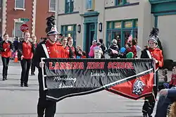 Lansing High School band marching in the 2015 Veterans Day Parade | |
 Location within Leavenworth County and Kansas | |
 KDOT map of Leavenworth County (legend) | |
| Coordinates: 39°14′55″N 94°53′31″W | |
| Country | United States |
| State | Kansas |
| County | Leavenworth |
| Incorporated | 1959 |
| Named for | James Lansing |
| Government | |
| • Mayor | Mike Smith |
| • City Administrator | Tim Vandall [1] |
| Area | |
| • Total | 12.50 sq mi (32.37 km2) |
| • Land | 12.39 sq mi (32.09 km2) |
| • Water | 0.11 sq mi (0.28 km2) 0.88% |
| Elevation | 846 ft (258 m) |
| Population | |
| • Total | 11,265 |
| • Estimate (2016)[4] | 11,849 |
| • Density | 900/sq mi (350/km2) |
| Time zone | UTC-6 (CST) |
| • Summer (DST) | UTC-5 (CDT) |
| ZIP code | 66043 |
| Area code | 913 |
| FIPS code | 20-38650 [5] |
| GNIS ID | 0478431 [6] |
| Website | City website |
The Lansing Correctional Facility (used to be called the Kansas State Penitentiary), which includes the state's main maximum-security prison, is in Lansing.
History
Lansing is named for James Lansing. He was a pioneer settler.[8]
Geography
Lansing is at 39°14′55″N 94°53′31″W (39.248689, -94.891880).[9] The city is on the western bank of the Missouri River. The river also creates the Kansas-Missouri state border. It is bordered by the city of Leavenworth to the north; Kansas City is less than a half-hour to the southeast. U.S. Route 73 goes through the city.
The United States Census Bureau says that the city has a total area of 12.50 square miles (32.37 km2). Of that,, 12.39 square miles (32.09 km2) is land and 0.11 square miles (0.28 km2) is water.[2]
People
| Historical population | |||
|---|---|---|---|
| Census | Pop. | %± | |
| 1880 | 933 | — | |
| 1890 | 1,468 | 57.3% | |
| 1960 | 1,264 | — | |
| 1970 | 3,797 | 200.4% | |
| 1980 | 5,307 | 39.8% | |
| 1990 | 7,120 | 34.2% | |
| 2000 | 9,199 | 29.2% | |
| 2010 | 11,265 | 22.5% | |
| 2016 (est.) | 11,849 | [4] | 5.2% |
| U.S. Decennial Census | |||

Education
Lansing Unified School District (USD 469), with four schools, has more than 2,000 students.[10]
- Lansing Elementary School, grades K–3
- Lansing Intermediate School, grades 4–5
- Lansing Middle School, grades 6–8
- Lansing High School, grades 9–12
References
- "City of Lansing Official Website - City Administrator". Archived from the original on 2016-03-04. Retrieved 2019-07-12.
- "US Gazetteer files 2010". United States Census Bureau. Archived from the original on 2012-07-02. Retrieved 2012-07-06.
- "American FactFinder". United States Census Bureau. Retrieved 2012-07-06.
- "Population and Housing Unit Estimates". Retrieved June 9, 2017.
- "American FactFinder". United States Census Bureau. Retrieved 2008-01-31.
- "US Board on Geographic Names". United States Geological Survey. 2007-10-25. Retrieved 2008-01-31.
- "2010 City Population and Housing Occupancy Status". U.S. Census Bureau. Archived from the original on July 26, 2011. Retrieved March 6, 2011.
- Heim, Michael (2007). Exploring Kansas Highways. Exploring America's Highway. p. 52. ISBN 978-0-9744358-8-6.
- "US Gazetteer files: 2010, 2000, and 1990". United States Census Bureau. 2011-02-12. Retrieved 2011-04-23.
- "Lansing schools". GreatSchools.net. Retrieved 2006-07-16.
Other websitess
- City
- City of Lansing
- "Lansing - Directory of Public Officials". Archived from the original on 2015-10-26.
- Lansing, Kansas at the Open Directory Project
- Maps
- Lansing City Map, KDOT
Kansas City metropolitan area's cities and counties | ||
|---|---|---|
| Central city |  | |
| Largest cities (over 100,000 in 2000) | ||
| Medium-sized cities (10,000 to 100,000 in 2000) | ||
| Smaller Cities (between 5,000 and 9,900 in 2010) |
| |
| Counties | ||
