Republic County, Kansas
Republic County (standard abbreviation: RP) is a county in the state of Kansas. It is south from the Nebraska border. In 2010 census, 4,980 people lived there.[1] The county seat is Belleville. Belleville is also the biggest city in Republic County.[2]
Republic County | |
|---|---|
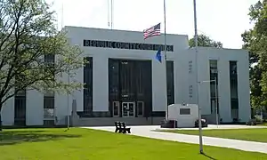 Republic County Courthouse in Belleville | |
 Location within the U.S. state of Kansas | |
 Kansas's location within the U.S. | |
| Coordinates: 39°57′34″N 97°25′28″W | |
| Country | |
| State | |
| Founded | February 27, 1860 |
| Named for | Republican River |
| Seat | Belleville |
| Largest city | Belleville |
| Area | |
| • Total | 720.31 sq mi (1,865.6 km2) |
| • Land | 716.38 sq mi (1,855.4 km2) |
| • Water | 3.93 sq mi (10.2 km2) 0.55%% |
| Population | |
| • Estimate (2016) | 4,699 |
| • Density | 7.2/sq mi (2.8/km2) |
| Time zone | UTC−6 (Central) |
| • Summer (DST) | UTC−5 (CDT) |
| Congressional district | 1st |
| Website | RepublicCounty.org |

History
Indian tribes lived in the area before white settlers came. The tribes included the Pawnee, Iowa, and Otoe.[3]
In 1860, Republic County was created by the Kansas legislature. The county is named after the Republican River.[3]
Daniel and Conrad Myers were the first white settlers. They arrived in February 1861.[4] By 1868, Republic County was holding elections.[5]
After the Civil War and during the 19th century, a lot of European immigrants (mostly from Sweden and the Czech Republic) came to Belleville and the area around it.[6][7][8]
In 1887, Atchison, Topeka and Santa Fe Railway built a railroad from Neva (3 miles west of Strong City) to Superior, Nebraska. This railroad connected Strong City, Neva, Rockland, Diamond Springs, Burdick, Lost Springs, Jacobs, Hope, Navarre, Enterprise, Abilene, Talmage, Manchester, Longford, Oak Hill, Miltonvale, Aurora, Huscher, Concordia, Kackley, Courtland, Webber, Superior. This railroad was called "Strong City and Superior line". Later the name was shortened to the "Strong City line".
Geography
The U.S. Census Bureau says that the county has a total area of 720.31 square miles (1,865.6 km2). Of that, 716.38 square miles (1,855.4 km2) (or 99.45%) is land and 3.93 square miles (10.2 km2) (or 0.55%) is water.[9][10]
People

| Historical population | |||
|---|---|---|---|
| Census | Pop. | %± | |
| 1870 | 1,281 | — | |
| 1880 | 14,913 | 1,064.2% | |
| 1890 | 19,002 | 27.4% | |
| 1900 | 18,248 | −4.0% | |
| 1910 | 17,447 | −4.4% | |
| 1920 | 15,855 | −9.1% | |
| 1930 | 14,745 | −7.0% | |
| 1940 | 13,124 | −11.0% | |
| 1950 | 11,478 | −12.5% | |
| 1960 | 9,768 | −14.9% | |
| 1970 | 8,498 | −13.0% | |
| 1980 | 7,569 | −10.9% | |
| 1990 | 6,482 | −14.4% | |
| 2000 | 5,835 | −10.0% | |
| 2010 | 4,980 | −14.7% | |
| 2016 (est.) | 4,699 | [11] | −5.6% |
| U.S. Decennial Census[12] 1790-1960[13] 1900-1990[14] 1990-2000[15] 2010-2016[1] | |||
Government
Presidential elections
| Year | Republican | Democratic | Third parties |
|---|---|---|---|
| 2016 | 80.0% 2,024 | 14.8% 375 | 5.1% 130 |
| 2012 | 79.5% 2,134 | 17.8% 477 | 2.8% 75 |
| 2008 | 74.1% 1,978 | 24.0% 640 | 2.0% 53 |
| 2004 | 77.5% 2,238 | 21.0% 607 | 1.5% 44 |
| 2000 | 75.0% 2,239 | 20.2% 604 | 4.8% 142 |
| 1996 | 70.0% 2,283 | 21.1% 688 | 9.0% 292 |
| 1992 | 46.4% 1,767 | 24.7% 939 | 28.9% 1,100 |
| 1988 | 67.8% 2,346 | 30.9% 1,069 | 1.4% 47 |
| 1984 | 76.5% 3,009 | 22.6% 887 | 1.0% 38 |
| 1980 | 73.6% 3,031 | 20.6% 850 | 5.8% 239 |
| 1976 | 57.4% 2,294 | 40.5% 1,617 | 2.1% 83 |
| 1972 | 71.8% 2,921 | 26.0% 1,059 | 2.2% 88 |
| 1968 | 66.3% 2,841 | 27.7% 1,187 | 6.1% 260 |
| 1964 | 51.7% 2,414 | 47.5% 2,222 | 0.8% 38 |
| 1960 | 65.6% 3,358 | 33.7% 1,724 | 0.7% 35 |
| 1956 | 68.8% 3,621 | 30.6% 1,613 | 0.6% 32 |
| 1952 | 76.7% 4,573 | 22.8% 1,358 | 0.5% 30 |
| 1948 | 60.4% 3,375 | 37.8% 2,109 | 1.8% 102 |
| 1944 | 66.5% 3,802 | 33.1% 1,891 | 0.4% 22 |
| 1940 | 63.5% 4,450 | 35.9% 2,511 | 0.6% 42 |
| 1936 | 52.6% 3,830 | 47.1% 3,427 | 0.3% 23 |
| 1932 | 38.6% 2,655 | 59.6% 4,105 | 1.8% 127 |
| 1928 | 68.2% 4,324 | 30.9% 1,956 | 1.0% 61 |
| 1924 | 60.0% 3,671 | 26.4% 1,616 | 13.6% 835 |
| 1920 | 67.3% 3,661 | 30.7% 1,672 | 2.0% 107 |
| 1916 | 41.7% 2,882 | 55.0% 3,806 | 3.4% 232 |
| 1912 | 21.7% 895 | 44.1% 1,816 | 34.1% 1,405 |
| 1908 | 51.8% 2,156 | 45.8% 1,905 | 2.5% 102 |
| 1904 | 69.5% 2,658 | 24.6% 941 | 5.9% 225 |
| 1900 | 55.7% 2,499 | 42.9% 1,925 | 1.5% 65 |
| 1896 | 50.9% 2,033 | 47.9% 1,910 | 1.2% 49 |
| 1892 | 50.0% 2,167 | 50.0% 2,164 | |
| 1888 | 63.8% 2,595 | 29.6% 1,205 | 6.6% 269 |
Republic County is very Republican. No Democratic presidential candidate has won the county except for Franklin D. Roosevelt in 1932 and Woodrow Wilson in 1912 and 1916. Since 1996, the Republican candidate has won seventy percent of the county’s vote.
Education
Unified school districts
- Pike Valley USD 426 (Scandia, Courtland and western half of county)
- Republic County USD 109 (Belleville, Cuba and eastern half of county)
Communities

Incorporated cities
- Agenda
- Belleville
- Courtland
- Cuba
- Munden
- Narka
- Republic
- Scandia
References
- "State & County QuickFacts". United States Census Bureau. Archived from the original on July 17, 2011. Retrieved July 28, 2014.
- "Find a County". National Association of Counties. Retrieved 2011-06-07.
- Savage., I. O. (1901). Carolyn Ward, transcribed July 2006 (ed.). A history of Republic County, Kansas : embracing a full and complete account of all the leading events in its history, from its first settlement down to June 1, '01. Jones & Chubbic, Beloit, KS. p. 32. Archived from the original on 2013-07-05. Retrieved 2019-07-26.
- Savage., I. O. (1901). Carolyn Ward, transcribed July 2006 (ed.). A history of Republic County, Kansas : embracing a full and complete account of all the leading events in its history, from its first settlement down to June 1, '01. Jones & Chubbic, Beloit, KS. p. 35. Archived from the original on 2013-07-05. Retrieved 2019-07-26.
- Savage., I. O. (1901). Carolyn Ward, transcribed July 2006 (ed.). A history of Republic County, Kansas : embracing a full and complete account of all the leading events in its history, from its first settlement down to June 1, '01. Jones & Chubbic, Beloit, KS. p. 115. Archived from the original on 2013-07-05. Retrieved 2019-07-26.
- I. O. Savage, History of Republic County (1883), p. 68; New Scandinavia's Ninety-Three Years, 1868–1961 (Scandia, 1961), pp. 3-5.
- Nemcova, Bozena. "People of Czech Bohemian Descent in Republic County, Kansas." Master's thesis, University of Kansas, 1950. (Reel: LM 205).
- https://www.kshs.org/p/bohemians-czechs-and-moravians-to-kansas-a-bibliography/13535 |Kansas Historical Society, Bohemians, Czechs, Moravians Bibliography
- "Census 2000 U.S. Gazetteer Files: Counties". United States Census. Retrieved 2011-02-13.
- "US Gazetteer files: 2010, 2000, and 1990". United States Census Bureau. 2011-02-12. Retrieved 2011-04-23.
- "Population and Housing Unit Estimates". Retrieved June 9, 2017.
- "U.S. Decennial Census". United States Census Bureau. Retrieved July 28, 2014.
- "Historical Census Browser". University of Virginia Library. Retrieved July 28, 2014.
- "Population of Counties by Decennial Census: 1900 to 1990". United States Census Bureau. Retrieved July 28, 2014.
- "Census 2000 PHC-T-4. Ranking Tables for Counties: 1990 and 2000" (PDF). United States Census Bureau. Retrieved July 28, 2014.
- "Dave Leip's Atlas of U.S. Presidential Elections".
More reading
- Standard Atlas of Republic County, Kansas; Geo. A. Ogle & Co; 66 pages; 1923.
- Standard Atlas of Republic County, Kansas; Geo. A. Ogle & Co; 58 pages; 1904.
- Atlas of Republic County, Kansas; Gillen & Davy; 47 pages; 1884.
Other websites
- County
- Other
- Maps
- Republic County maps: current, historic, KDOT
- Kansas highway maps: current, historic, KDOT
- Kansas railroad maps: current, 1996, 1915, KDOT and Kansas Historical Society
