Jetmore, Kansas
Jetmore is a city in Hodgeman County, Kansas, United States.[6] It is also the county seat of Hodgeman County. In 2010, 867 people lived there.[7]
Jetmore, Kansas | |
|---|---|
City and County seat | |
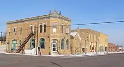 West side of Main Street (2010) | |
 Location within Hodgeman County and Kansas | |
 KDOT map of Hodgeman County (legend) | |
| Coordinates: 38°5′3″N 99°53′46″W | |
| Country | United States |
| State | Kansas |
| County | Hodgeman |
| Area | |
| • Total | 4.49 sq mi (11.63 km2) |
| • Land | 4.49 sq mi (11.63 km2) |
| • Water | 0 sq mi (0 km2) |
| Elevation | 2,303 ft (702 m) |
| Population | |
| • Total | 867 |
| • Estimate (2016)[3] | 842 |
| • Density | 190/sq mi (75/km2) |
| Time zone | UTC-6 (CST) |
| • Summer (DST) | UTC-5 (CDT) |
| ZIP code | 67854 |
| Area code | 620 |
| FIPS code | 20-35450 [4] |
| GNIS ID | 0475917 [5] |
| Website | City Website |
History
Jetmore was first called Buckner. It was planned as Buckner in 1879.[8][9] The name was changed to Jetmore in 1880 in honor of Col. Abraham Buckles Jetmore.[10][11] Abraham Jetmore was lawyer from Topeka. He was important in being able to get a railroad line through the city. He also helped make Jetmore the county seat.[12]
Geography
Jetmore is at 38°5′3″N 99°53′46″W (38.084137, -99.895999).[13] The United States Census Bureau says that the city has a total area of 4.49 square miles (11.63 km2). All of it is land.[1] The Buckner Creek, a tributary of the Pawnee River, flows through Jetmore.
The surface rocks in this area include Greenhorn limestone and Graneros shale.[14][15]
Climate
Jetmore has hot, humid summers and generally mild to cool winters. The Köppen Climate Classification system says that Jetmore has a humid subtropical climate, abbreviated "Cfa" on climate maps.[16]
People
| Historical population | |||
|---|---|---|---|
| Census | Pop. | %± | |
| 1890 | 324 | — | |
| 1900 | 230 | −29.0% | |
| 1910 | 317 | 37.8% | |
| 1920 | 559 | 76.3% | |
| 1930 | 914 | 63.5% | |
| 1940 | 881 | −3.6% | |
| 1950 | 988 | 12.1% | |
| 1960 | 1,028 | 4.0% | |
| 1970 | 936 | −8.9% | |
| 1980 | 862 | −7.9% | |
| 1990 | 850 | −1.4% | |
| 2000 | 903 | 6.2% | |
| 2010 | 867 | −4.0% | |
| 2016 (est.) | 842 | [3] | −2.9% |
| U.S. Decennial Census | |||
References
- "US Gazetteer files 2010". United States Census Bureau. Archived from the original on 2012-01-25. Retrieved 2012-07-06.
- "American FactFinder". United States Census Bureau. Retrieved 2012-07-06.
- "Population and Housing Unit Estimates". Retrieved June 9, 2017.
- "American FactFinder". United States Census Bureau. Archived from the original on 2013-09-11. Retrieved 2008-01-31.
- "US Board on Geographic Names". United States Geological Survey. 2007-10-25. Retrieved 2008-01-31.
- "Find a County". National Association of Counties. Archived from the original on 2011-05-31. Retrieved 2011-06-07.
- "2010 City Population and Housing Occupancy Status". U.S. Census Bureau. Archived from the original on July 21, 2011. Retrieved March 27, 2011.
- Kansas State Historical Society (1916). Biennial Report of the Board of Directors of the Kansas State Historical Society. Kansas State Printing Plant. p. 206.
- Blackmar, Frank Wilson (1912). Kansas: A Cyclopedia of State History. Standard Publishing Company. p. 28.
- Bio of Abraham Buckles Jetmore in History of Kansas Archived 2006-11-06 at the Wayback Machine
- Gannett, Henry (1905). The Origin of Certain Place Names in the United States. Govt. Print. Off. p. 169.
- History of Jetmore, Kansas Archived 2009-04-21 at the Wayback Machine Another history of Jetmore Archived 2017-06-19 at the Wayback Machine
- "US Gazetteer files: 2010, 2000, and 1990". United States Census Bureau. 2011-02-12. Retrieved 2011-04-23.
- "KGS--Geologic Map--Hodgeman". Retrieved 2016-04-10.
- "KGS--Geology of Ness and Hodgeman Counties--Exposed Rocks". Retrieved 2016-04-10.
- Climate Summary for Jetmore, Kansas
Other websites
- City
- Schools
- USD 227, local school district
- Historical
- Maps
- Jetmore City Map, KDOT
Municipalities and communities of Hodgeman County, Kansas, United States | ||
|---|---|---|
| Cities |
|  Map of Kansas highlighting Hodgeman County |
| Townships |
| |
