Bayenghem-lès-Seninghem
Bayenghem-lès-Seninghem (French pronunciation: [bajɑ̃ɡɑ̃ lɛ sənɛ̃ɡɑ̃], literally Bayenghem near Seninghem; West Flemish: Baaiengem) is a commune in the Pas-de-Calais department in the Hauts-de-France region in northern France.
Bayenghem-lès-Seninghem
Baaiengem | |
|---|---|
 The church of Bayenghem-lès-Seninghem | |
 Coat of arms | |
Location of Bayenghem-lès-Seninghem | |
 Bayenghem-lès-Seninghem 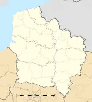 Bayenghem-lès-Seninghem | |
| Coordinates: 50°42′03″N 2°04′39″E | |
| Country | France |
| Region | Hauts-de-France |
| Department | Pas-de-Calais |
| Arrondissement | Saint-Omer |
| Canton | Lumbres |
| Intercommunality | Pays de Lumbres |
| Government | |
| • Mayor (2020–2026) | Jean-François Denecque[1] |
| Area 1 | 3.33 km2 (1.29 sq mi) |
| Population (2021)[2] | 337 |
| • Density | 100/km2 (260/sq mi) |
| Time zone | UTC+01:00 (CET) |
| • Summer (DST) | UTC+02:00 (CEST) |
| INSEE/Postal code | 62088 /62380 |
| Elevation | 50–170 m (160–560 ft) (avg. 64 m or 210 ft) |
| 1 French Land Register data, which excludes lakes, ponds, glaciers > 1 km2 (0.386 sq mi or 247 acres) and river estuaries. | |
Geography
A village located 10 miles (16 km) southwest of Saint-Omer, on the D204 road, just off the N42.
Population
| Year | Pop. | ±% p.a. |
|---|---|---|
| 1968 | 192 | — |
| 1975 | 203 | +0.80% |
| 1982 | 235 | +2.11% |
| 1990 | 294 | +2.84% |
| 1999 | 304 | +0.37% |
| 2009 | 332 | +0.88% |
| 2014 | 325 | −0.43% |
| 2020 | 328 | +0.15% |
| Source: INSEE[3] | ||
Sights
- St. Martin's sixteenth-century church.
References
- "Répertoire national des élus: les maires". data.gouv.fr, Plateforme ouverte des données publiques françaises (in French). 9 August 2021.
- "Populations légales 2021". The National Institute of Statistics and Economic Studies. 28 December 2023.
- Population en historique depuis 1968, INSEE
Wikimedia Commons has media related to Bayenghem-lès-Seninghem.
This article is issued from Wikipedia. The text is licensed under Creative Commons - Attribution - Sharealike. Additional terms may apply for the media files.