DE postcode area
The DE postcode area, also known as the Derby postcode area,[2] is a group of 23 postcode districts in central England, within 11 post towns. These cover south and central Derbyshire (including Derby, Alfreton, Ashbourne, Bakewell, Belper, Heanor, Ilkeston, Matlock, Ripley and Swadlincote), parts of east Staffordshire (including Burton upon Trent) and north-west Leicestershire, and very small parts of Nottinghamshire.
Template:Attached KML/DE postcode area
KML is from Wikidata
Derby | |
|---|---|
 DE | |
| Coordinates: 52.932°N 1.499°W | |
| Country | United Kingdom |
| Postcode area | DE |
| Postcode area name | Derby |
| Post towns | 11 |
| Postcode districts | 25 |
| Postcode sectors | 129 |
| Postcodes (live) | 17,235 |
| Postcodes (total) | 30,008 |
| Statistics as at May 2020[1] | |
Coverage
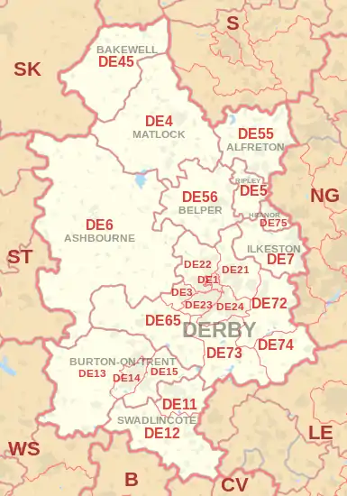
The approximate coverage of the postcode districts:
| Postcode district | Post town | Coverage | Local authority area(s) |
|---|---|---|---|
| DE1 | DERBY | Derby city centre | Derby |
| DE3 | DERBY | Derby (Mickleover) | Derby, South Derbyshire |
| DE4 | MATLOCK | Sector 2:Darley Dale, Beeley, Rowsley, Winster, Darley Bridge, Elton, Bonsall Sector 3:Matlock, Matlock Bath, Cromford Sector 4: Middleton-by-Wirksworth, Wirksworth, Bolehill Sector 5: Crich, Holloway, Lea, Tansley |
Derbyshire Dales, Amber Valley |
| DE5 | RIPLEY | Ripley, Codnor, Denby, Waingroves, Butterley, Pentrich | Amber Valley |
| DE6 | ASHBOURNE | Ashbourne, Hulland Ward, Weston Underwood | Derbyshire Dales, Amber Valley, South Derbyshire, Derby, East Staffordshire |
| DE7 | ILKESTON | Horsley Woodhouse, Ilkeston, Morley, West Hallam | Erewash, Amber Valley, Broxtowe |
| DE11 | SWADLINCOTE | Swadlincote, Church Gresley, Woodville, Newhall, Hartshorne, Castle Gresley, Blackfordby, Albert Village | South Derbyshire, North West Leicestershire |
| DE12 | SWADLINCOTE | Appleby Magna, Donisthorpe, Linton, Measham, Overseal, Rosliston, Walton-on-Trent | North West Leicestershire, South Derbyshire |
| DE13 | BURTON-ON-TRENT | Alrewas, Barton-under-Needwood, Rolleston on Dove, Tutbury | East Staffordshire, Lichfield |
| DE14 | BURTON-ON-TRENT | Branston, Burton upon Trent | East Staffordshire, South Derbyshire |
| DE15 | BURTON-ON-TRENT | Bretby, Stapenhill, Newton Solney, Winshill | East Staffordshire, South Derbyshire |
| DE21 | DERBY | Derby (Chaddesden, Oakwood, Spondon); Breadsall, Horsley, Little Eaton | Derby, Erewash, Amber Valley |
| DE22 | DERBY | Derby (Allestree, Darley Abbey, Mackworth (estate)); Kedleston, Mackworth (village), Quarndon | Derby, Amber Valley |
| DE23 | DERBY | Derby (Heatherton Village, Littleover, Normanton, Pear Tree, Sunny Hill) Highfields suburb | Derby, South Derbyshire |
| DE24 | DERBY | Derby (Allenton, Alvaston, Boulton, Osmaston, Shelton Lock, Sinfin, Wilmorton); Stenson Fields | Derby, South Derbyshire |
| DE45 | BAKEWELL | Ashford-in-the-Water, Bakewell, Baslow, Chatsworth, Edensor, Hassop, Monyash, Youlgreave | Derbyshire Dales |
| DE55 | ALFRETON | Sector 1: Swanwick Sectors 2 and 3: Alfreton, South Normanton Sector 4: Riddings, Greenhill Lane, Leabrooks, Somercotes Sector 5: Tibshelf, Newton, Blackwell, Hilcote Sector 6: Wessington, Higham, Stonebroom, Morton, Shirland Sector 7: Alfreton, South Wingfield |
Amber Valley, Bolsover |
| DE56 | BELPER | Ambergate, Belper, Duffield, Heage, Holbrook, Kilburn, Milford | Amber Valley |
| DE65 | DERBY | Burnaston, Egginton, Etwall, Findern, Hatton, Hilton, Milton, Repton, Willington | South Derbyshire |
| DE72 | DERBY | Ambaston, Aston-on-Trent, Borrowash, Breaston, Church Wilne, Draycott, Elvaston, Ockbrook, Risley, Shardlow, Weston-on-Trent | Erewash, South Derbyshire, North West Leicestershire |
| DE73 | DERBY | Derby (Chellaston); Barrow upon Trent, Ingleby, Melbourne, Stanton by Bridge, Swarkestone, Ticknall | Derby, South Derbyshire |
| DE74 | DERBY | Castle Donington, Kegworth, Diseworth, Hemington, Lockington, East Midlands Airport | North West Leicestershire, Rushcliffe |
| DE75 | HEANOR | Heanor, Loscoe, Shipley | Amber Valley |
| DE99 | DERBY | non-geographic |
Map
Template:Attached KML/DE postcode area
KML is from Wikidata
References
- "ONS Postcode Directory Version Notes" (ZIP). National Statistics Postcode Products. Office for National Statistics. May 2020. Table 2. Retrieved 19 June 2020. Coordinates from mean of unit postcode points, "Code-Point Open". OS OpenData. Ordnance Survey. February 2012. Retrieved 21 April 2012.
- Royal Mail, Address Management Guide, (2004)
External links
This article is issued from Wikipedia. The text is licensed under Creative Commons - Attribution - Sharealike. Additional terms may apply for the media files.