LN postcode area
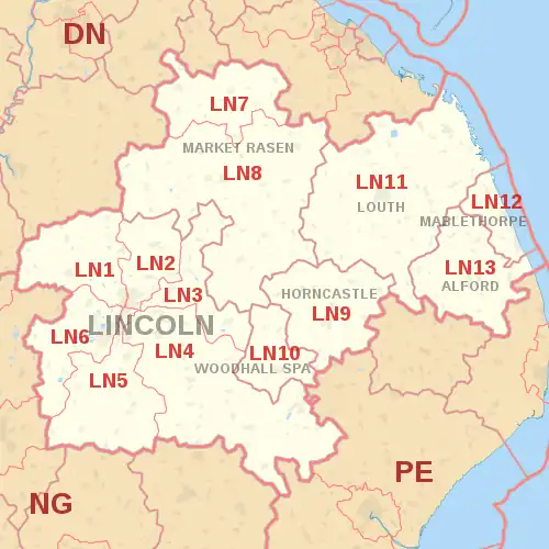
The LN postcode area, also known as the Lincoln postcode area,[2] is a group of thirteen postcode districts in eastern England, within seven post towns. These cover central Lincolnshire, including Lincoln, Alford, Horncastle, Louth, Mablethorpe, Market Rasen and Woodhall Spa.
Template:Attached KML/LN postcode area
KML is from Wikidata
Lincoln | |
|---|---|
 LN | |
| Coordinates: 53.256°N 0.349°W | |
| Country | United Kingdom |
| Postcode area | LN |
| Postcode area name | Lincoln |
| Post towns | 7 |
| Postcode districts | 13 |
| Postcode sectors | 49 |
| Postcodes (live) | 9,211 |
| Postcodes (total) | 11,935 |
| Statistics as at May 2020[1] | |
Coverage
The approximate coverage of the postcode districts:
| Postcode district | Post town | Coverage | Local authority area(s) |
|---|---|---|---|
| LN1 | LINCOLN | Saxilby, Stow, Sturton, City Centre | Lincoln, West Lindsey |
| LN2 | LINCOLN | Nettleham, Ermine & St Giles Estates, Welton, Sudbrooke, Dunholme, Grange de Lings. | Lincoln, West Lindsey |
| LN3 | LINCOLN | Fiskerton, Cherry Willingham, Lincoln, Bardney, Reepham | Lincoln, West Lindsey, North Kesteven, |
| LN4 | LINCOLN | Branston, Canwick, Coningsby, Dunston, Heighington, Nocton, Washingborough, Timberland, Martin, Ashby de la Launde, Scopwick, Holland Fen, Metheringham | Lincoln, North Kesteven, East Lindsey, Boston |
| LN5 | LINCOLN | Waddington, Bassingham, Carlton Le Moorland, Harmston, Haddington, Thurlby, Aubourn | Lincoln, North Kesteven |
| LN6 | LINCOLN | North Hykeham, South Hykeham, Birchwood, Skellingthorpe, Doddington, Whisby, Eagle, North Scarle, Thorpe on the Hill, Witham St Hughs, Swinderby, Norton Disney, Stapleford | Lincoln, North Kesteven |
| LN7 | MARKET RASEN | Nettleton, Caistor | West Lindsey, North Lincolnshire |
| LN8 | MARKET RASEN | Market Rasen | West Lindsey, East Lindsey, North East Lincolnshire |
| LN9 | HORNCASTLE | Horncastle, Tetford, Salmonby, Minting, Belchford, West Ashby, Hemingby, Baumber, Low Toynton, High Toynton, Fulletby, Greetham, Ashby Puerorum, Edlington, Wispington, Mareham on the Hill, Haltham, Winceby, Hameringham, Dalderby, Thornton, Langton, Old Woodhall, Oxcombe, Scrafield | East Lindsey |
| LN10 | WOODHALL SPA | Woodhall Spa, Kirkstead, Roughton, Bucknall, Horsington, Kirkby on Bain, Stixwould | East Lindsey, North Kesteven |
| LN11 | LOUTH | Louth | East Lindsey |
| LN12 | MABLETHORPE | Mablethorpe, Sutton-on-Sea, Theddlethorpe | East Lindsey |
| LN13 | ALFORD | East Lindsey |
Map
Template:Attached KML/LN postcode area
KML is from Wikidata
References
- "ONS Postcode Directory Version Notes" (ZIP). National Statistics Postcode Products. Office for National Statistics. May 2020. Table 2. Retrieved 19 June 2020. Coordinates from mean of unit postcode points, "Code-Point Open". OS OpenData. Ordnance Survey. February 2012. Retrieved 21 April 2012.
- Royal Mail, Address Management Guide, (2004)
External links
This article is issued from Wikipedia. The text is licensed under Creative Commons - Attribution - Sharealike. Additional terms may apply for the media files.