PR postcode area
The PR postcode area, also known as the Preston postcode area,[2] is a group of eleven postcode districts in North West England which together cover northern Merseyside and parts of central and southern Lancashire. Its four post towns are Chorley, Leyland, Southport, and Preston.
Template:Attached KML/PR postcode area
KML is from Wikidata
Preston | |
|---|---|
 PR | |
| Coordinates: 53.723°N 2.756°W | |
| Country | United Kingdom |
| Postcode area | PR |
| Postcode area name | Preston |
| Post towns | 4 |
| Postcode districts | 13 |
| Postcode sectors | 83 |
| Postcodes (live) | 13,061 |
| Postcodes (total) | 19,936 |
| Statistics as at May 2020[1] | |
Coverage
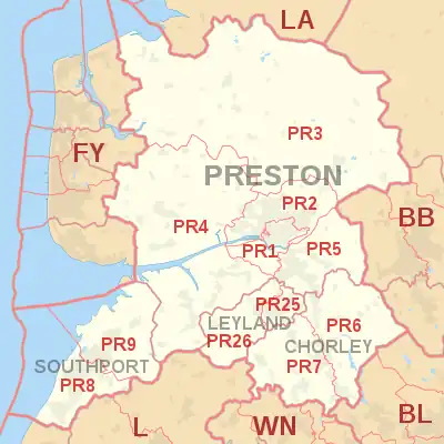
The approximate coverage of the postcode districts:
| Postcode district | Post town | Coverage | Local authority area(s) |
|---|---|---|---|
| PR0 | PRESTON | Express Gifts | non-geographic[3] |
| PR1 | PRESTON | City Centre, Avenham, Broadgate, Deepdale, Fishwick, St. Matthew's, Penwortham | City of Preston, South Ribble |
| PR2 | PRESTON | Ashton On Ribble, Brookfield, Cadley, Fulwood, Grimsargh, Haighton, Ingol, Larches, Lea, Ribbleton, Riversway, Sharoe Green, Tanterton | City of Preston |
| PR3 | PRESTON | Barnacre-with-Bonds, Barton, Bilsborrow, Bonds, Bowgreave, Broughton, Cabus, Calder Vale, Chipping, Claughton, Forton, Garstang, Goosnargh, Great Eccleston, Inglewhite, Little Eccleston, Longridge, Myerscough, Oakenclough, Pilling, Ribchester, St Michael's On Wyre, Scorton, Whittingham, Winmarleigh | Fylde, City of Preston, Ribble Valley, Wyre |
| PR4 | PRESTON | Becconsall, Catforth, Clifton, Cottam, Eaves, Elswick, Freckleton, Hesketh Bank, Hutton, Inskip, Kirkham, Lea Town, Longton, Much Hoole, New Longton, Newton, Tarleton, Thistleton, Treales, Roseacre and Wharles, Walmer Bridge, Warton, Wesham, Woodplumpton, Wrea Green | Fylde, City of Preston, South Ribble, West Lancashire |
| PR5 | PRESTON | Bamber Bridge, Coupe Green, Cuerdale, Cuerden, Gregson Lane, Higher Walton, Hoghton, Lostock Hall, Riley Green, Samlesbury, Walton-le-Dale, Walton Park, Walton Summit | South Ribble, Chorley |
| PR6 | CHORLEY | Abbey Village, Adlington, Anderton, Anglezarke, Astley Village, Brindle, Brinscall, Clayton-le-Woods, Heapey, Heath Charnock, Wheelton, White Coppice, Whittle-le-Woods, Withnell | Chorley |
| PR7 | CHORLEY | Adlington, Buckshaw Village, Charnock Richard, Coppull, Eccleston, Euxton, Heath Charnock, Heskin | Chorley |
| PR8 | SOUTHPORT | Ainsdale, Birkdale, Blowick, Scarisbrick | Sefton, West Lancashire |
| PR9 | SOUTHPORT | Banks, Churchtown, Crossens, Marshside | Sefton, West Lancashire |
| PR11 | PRESTON | Great Universal Stores/Department for Work and Pensions delivering to its address in PR1[3] | non-geographic |
| PR25 | LEYLAND | Leyland, Clayton-le-Woods, Cuerden, Farington | South Ribble, Chorley |
| PR26 | LEYLAND | Leyland, Bretherton, Croston, Farington Moss, Moss Side, Ulnes Walton | South Ribble, Chorley |
The PR25 and PR26 districts were formed out of the PR5 district in January 2001. Leyland became a new post town at this time, having previously been part of the Preston post town.[4]
Map
Template:Attached KML/PR postcode area
KML is from Wikidata
References
- "ONS Postcode Directory Version Notes" (ZIP). National Statistics Postcode Products. Office for National Statistics. May 2020. Table 2. Retrieved 19 June 2020. Coordinates from mean of unit postcode points, "Code-Point Open". OS OpenData. Ordnance Survey. February 2012. Retrieved 21 April 2012.
- Royal Mail, Address Management Guide, (2004)
- "Royal Mail non-geographic postcodes" (PDF). Royal Mail. 7 March 2007. Retrieved 10 March 2008.
- "Which districts have been recoded by the Royal Mail?". Experian QAS. Retrieved 22 October 2016.
External links
This article is issued from Wikipedia. The text is licensed under Creative Commons - Attribution - Sharealike. Additional terms may apply for the media files.