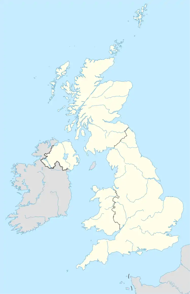
PL postcode area
The PL postcode area, also known as the Plymouth postcode area,[2] is a group of 35 postcode districts in South West England, within 25 post towns. These cover west Devon (including Plymouth, Tavistock, Ivybridge, Yelverton and Lifton) and east Cornwall (including St Austell, Bodmin, Liskeard, Launceston, Looe, Saltash, Torpoint, Callington, Wadebridge, Boscastle, Calstock, Camelford, Delabole, Fowey, Gunnislake, Lostwithiel, Padstow, Par, Port Isaac and Tintagel).
Template:Attached KML/PL postcode area
KML is from Wikidata
Plymouth | |
|---|---|
 PL | |
| Coordinates: 50.432°N 4.337°W | |
| Country | United Kingdom |
| Postcode area | PL |
| Postcode area name | Plymouth |
| Post towns | 25 |
| Postcode districts | 36 |
| Postcode sectors | 99 |
| Postcodes (live) | 17,524 |
| Postcodes (total) | 22,439 |
| Statistics as at May 2020[1] | |
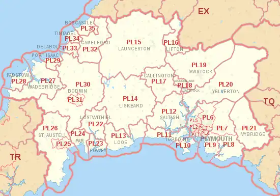
Coverage
The approximate coverage of the postal districts:[3][4]
| Postcode district | Post town | Coverage | Local authority area(s) |
|---|---|---|---|
| PL1 | PLYMOUTH | Plymouth City Centre, Barbican, Devonport, The Hoe, Millbridge, Stoke, Stonehouse | Plymouth City Council |
| PL2 | PLYMOUTH | Beacon Park, Ford, Keyham, North Prospect, Pennycross, Home Park | Plymouth City Council |
| PL3 | PLYMOUTH | Efford, Hartley, Laira, Mannamead, Milehouse, Peverell, Higher Compton | Plymouth City Council |
| PL4 | PLYMOUTH | Lipson, Mount Gould, Mutley, Greenbank, Prince Rock, St. Judes, Barbican (north) | Plymouth City Council |
| PL5 | PLYMOUTH | Crownhill, Ernesettle, Honicknowle, Whitleigh, St. Budeaux, Tamerton Foliot | Plymouth City Council |
| PL6 | PLYMOUTH | Derriford, Eggbuckland, Estover, Leigham, Roborough, Southway Lopwell, Woolwell, Bickleigh |
Plymouth City Council South Hams |
| PL7 | PLYMOUTH | Plympton, Sparkwell | Plymouth City Council South Hams |
| PL8 | PLYMOUTH | Brixton, Newton Ferrers, Noss Mayo, Yealmpton | South Hams |
| PL9 | PLYMOUTH | Plymstock, Heybrook Bay, Mount Batten, Wembury | Plymouth City Council |
| PL10 | TORPOINT | Cawsand, Cremyll, Fort Picklecombe, Freathy, Kingsand, Millbrook | Cornwall Council |
| PL11 | TORPOINT | Torpoint, Antony, Crafthole, Downderry, Seaton, Sheviock, St John | Cornwall Council |
| PL12 | SALTASH | Saltash, Hatt, Landrake, St Germans, Tideford, Trerulefoot | Cornwall Council |
| PL13 | LOOE | Looe, Lansallos, Polperro | Cornwall Council |
| PL14 | LISKEARD | Liskeard, Dobwalls, Doublebois, Minions, St Cleer, St Ive, St Neot | Cornwall Council |
| PL15 | LAUNCESTON | Launceston, Bolventor, Lezant, South Petherwin, Treneglos | Cornwall Council, Torridge |
| PL16 | LIFTON | Lifton, Broadwoodwidger, Marystow | West Devon, Torridge |
| PL17 | CALLINGTON | Callington, Ashton, Bray Shop, Kelly Bray, South Hill | Cornwall Council |
| PL18 | CALSTOCK | Calstock | Cornwall Council |
| GUNNISLAKE | Gunnislake, Albaston | ||
| PL19 | TAVISTOCK | Tavistock, Bradstone, Mary Tavy, Morwellham, Peter Tavy, Whitchurch | West Devon |
| PL20 | YELVERTON | Yelverton, Bellever, Crapstone, Horrabridge, Postbridge, Princetown, Two Bridges | West Devon |
| PL21 | IVYBRIDGE | Ivybridge, Brownston, Cornwood, Ermington, Modbury, Ugborough | South Hams |
| PL22 | LOSTWITHIEL | Lostwithiel, Boconnoc, Lanlivery, Lerryn, St Veep | Cornwall Council |
| PL23 | FOWEY | Fowey, Bodinnick, Golant, Polruan | Cornwall Council |
| PL24 | PAR | Par, Polkerris, St Blazey, Tywardreath | Cornwall Council |
| PL25 | ST. AUSTELL | St Austell, Carlyon Bay, Charlestown, Trewoon | Cornwall Council |
| PL26 | ST. AUSTELL | East Portholland, Foxhole, Gorran Haven, Mevagissey, St Dennis, St Ewe, Sticker | Cornwall Council |
| PL27 | WADEBRIDGE | Wadebridge, Little Petherick, Polzeath, Rock, St Eval, St Minver, Trebetherick | Cornwall Council |
| PL28 | PADSTOW | Padstow, Crugmeer, Porthcothan, St Merryn, Trevone, Treyarnon | Cornwall Council |
| PL29 | PORT ISAAC | Port Isaac, Port Gaverne, Port Quin, St Endellion, Trelights | Cornwall Council |
| PL30 | BODMIN | Blisland, Lanivet, Luxulyan, Nanstallon, St Kew, St Mabyn, Temple, Withiel | Cornwall Council |
| PL31 | BODMIN | Bodmin, Dunmere | Cornwall Council |
| PL32 | CAMELFORD | Camelford, Davidstow, Lanteglos-by-Camelford, Otterham, Tresinney | Cornwall Council |
| PL33 | DELABOLE | Delabole, Trebarwith, Westdowns | Cornwall Council |
| PL34 | TINTAGEL | Tintagel, Bossiney, Trewarmett | Cornwall Council |
| PL35 | BOSCASTLE | Boscastle, Lesnewth, Trevalga | Cornwall Council |
| PL95 | PLYMOUTH | non-geographic |
Map
Template:Attached KML/PL postcode area
KML is from Wikidata
References
- "ONS Postcode Directory Version Notes" (ZIP). National Statistics Postcode Products. Office for National Statistics. May 2020. Table 2. Retrieved 19 June 2020. Coordinates from mean of unit postcode points, "Code-Point Open". OS OpenData. Ordnance Survey. February 2012. Retrieved 21 April 2012.
- Royal Mail, Address Management Guide, (2004)
- "Postal Codes United Kingdom". GeoNames. Retrieved 27 April 2009.
- Royal Mail (January 2012). "Non Geographic Codes" (PDF). Archived from the original (PDF) on 1 September 2012. Retrieved 6 July 2012.
External links
This article is issued from Wikipedia. The text is licensed under Creative Commons - Attribution - Sharealike. Additional terms may apply for the media files.