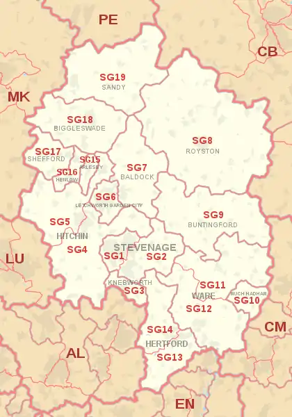
SG postcode area
The SG postcode area, also known as the Stevenage postcode area,[2] is a group of nineteen postcode districts in England, within fifteen post towns. These cover north Hertfordshire (including Stevenage, Baldock, Buntingford, Hertford, Hitchin, Knebworth, Letchworth, Much Hadham, Royston and Ware) and east Bedfordshire (including Arlesey, Biggleswade, Henlow, Sandy and Shefford), plus a small part of south-west Cambridgeshire and a very small part of Essex.
Template:Attached KML/SG postcode area
KML is from Wikidata
Stevenage | |
|---|---|
 SG | |
| Coordinates: 51.950°N 0.158°W | |
| Country | United Kingdom |
| Postcode area | SG |
| Postcode area name | Stevenage |
| Post towns | 15 |
| Postcode districts | 19 |
| Postcode sectors | 65 |
| Postcodes (live) | 11,823 |
| Postcodes (total) | 16,831 |
| Statistics as at May 2020[1] | |
Coverage
The approximate coverage of the postcode districts:[3]
| Postcode district | Post town | Coverage | Local authority area(s) |
|---|---|---|---|
| SG1 | STEVENAGE | North Stevenage including Old Town and Town Centre, Great Ashby | Stevenage, North Hertfordshire |
| SG2 | STEVENAGE | South Stevenage, Bragbury End, Walkern, Ardeley | Stevenage, East Hertfordshire |
| SG3 | KNEBWORTH | Knebworth, Datchworth, Woolmer Green | North Hertfordshire, East Hertfordshire, Welwyn Hatfield |
| SG4 | HITCHIN | Hitchin (east), Codicote, Kimpton, Weston, St Ippolyts, Little Wymondley, Whitwell, Graveley, Great Wymondley, Breachwood Green, Gosmore, Preston, St Paul's Walden, Langley, Bendish, Ley Green, King's Walden, Hall's Green | North Hertfordshire |
| SG5 | HITCHIN | Hitchin (west), Stotfold, Ickleford, Shillington, Offley, Fairfield, Pirton, Holwell, Apsley End, Hexton, Charlton, Astwick, Pegsdon, Higham Gobion | North Hertfordshire, Central Bedfordshire |
| SG6 | HITCHIN | non-geographic[4][5] | |
| SG6 | LETCHWORTH GARDEN CITY | Letchworth, Norton, Willian | North Hertfordshire |
| SG7 | BALDOCK | Baldock, Ashwell, Hinxworth, Wallington, Newnham, Bygrave, Radwell, Clothall, Odsey, Caldecote | North Hertfordshire, South Cambridgeshire |
| SG8 | ROYSTON | Royston, Abington Pigotts, Arrington, Barkway, Barley, Bassingbourn, Chrishall, Croydon, Fowlmere, Great Chishill, Guilden Morden, Heydon, Kelshall, Kneesworth, Litlington, Little Chishill, Melbourn, Meldreth, New Wimpole, Nuthampstead, Orwell, Reed, Shepreth, Shingay, Steeple Morden, Tadlow, Therfield, Thriplow, Wendy, Whaddon | North Hertfordshire, South Cambridgeshire, Uttlesford |
| SG9 | BUNTINGFORD | Buntingford, Cottered, Great Hormead, Furneux Pelham, Brent Pelham, Stocking Pelham, Hare Street, Anstey, Westmill, Wyddial, Buckland, Aspenden, Chipping, Sandon, Rushden, Throcking, Meesden, Little Hormead | East Hertfordshire, North Hertfordshire |
| SG10 | MUCH HADHAM | Much Hadham, Perry Green | East Hertfordshire |
| SG11 | WARE | Albury, Braughing, Bury Green, Colliers End, Haultwick, High Cross, Little Hadham, Nasty, Patmore Heath, Puckeridge, Standon, Standon Green End | East Hertfordshire |
| SG12 | WARE | Ware, Great Amwell, Stanstead Abbotts, Stanstead St Margarets, Widford, Hunsdon, Thundridge, Wadesmill, Dane End, Tonwell, Chapmore End, Wareside, Babbs Green, Sacombe | East Hertfordshire |
| SG13 | HERTFORD | Hertford (south and east), Newgate Street Village, Bayford, Brickendon | East Hertfordshire, Welwyn Hatfield |
| SG14 | HERTFORD | Hertford (north, west and town centre), Watton-at-Stone, Bramfield, Waterford | East Hertfordshire |
| SG15 | ARLESEY | Arlesey | Central Bedfordshire |
| SG16 | HENLOW | Henlow, Henlow Camp, Lower Stondon, Upper Stondon | Central Bedfordshire |
| SG17 | SHEFFORD | Shefford, Clifton, Meppershall, Campton, Chicksands, Beadlow, Deadman's Cross | Central Bedfordshire |
| SG18 | BIGGLESWADE | Biggleswade, Langford, Lower Caldecote, Northill, Upper Caldecote | Central Bedfordshire |
| SG19 | SANDY | Sandy, Potton, Gamlingay, Great Gransden, Wrestlingworth, Tempsford, Everton, Waresley, Little Gransden, Sutton, Beeston, Hatley, Eyeworth, Cockayne Hatley, Hatch, Thorncote Green, Budna | Central Bedfordshire, South Cambridgeshire, Huntingdonshire |
Map
Template:Attached KML/SG postcode area
KML is from Wikidata
See also
- Postcode Address File
- List of postcode areas in the United Kingdom
- Stevenage mail centre
References
- "ONS Postcode Directory Version Notes" (ZIP). National Statistics Postcode Products. Office for National Statistics. May 2020. Table 2. Retrieved 19 June 2020. Coordinates from mean of unit postcode points, "Code-Point Open". OS OpenData. Ordnance Survey. February 2012. Retrieved 21 April 2012.
- Royal Mail, Address Management Guide, (2004)
- Royal Mail, Postal Address Book: Anglia 2, Edition H, 2003
- "Non Geographic Codes" (PDF). Royal Mail Address Management Unit. July 2012. Archived from the original (PDF) on 16 September 2012. Retrieved 20 December 2012.
- "New sectors and localities to 14 December 2012" (PDF). Royal Mail Address Management Unit. 20 December 2012. Archived from the original (PDF) on 2 February 2015. Retrieved 20 December 2012.
External links
This article is issued from Wikipedia. The text is licensed under Creative Commons - Attribution - Sharealike. Additional terms may apply for the media files.