LE postcode area
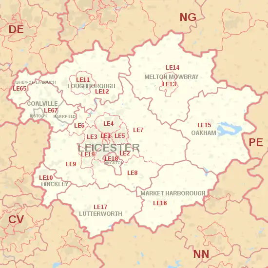
The LE postcode area, also known as the Leicester postcode area,[2] is a group of 21 postcode districts in central England, within 12 post towns. These cover most of Leicestershire (including Leicester, Loughborough, Hinckley, Melton Mowbray, Coalville, Market Harborough, Ashby de la Zouch, Lutterworth, Wigston, Markfield and Ibstock) and most of Rutland (including Oakham), plus small parts of south Nottinghamshire and north Northamptonshire, and very small parts of Derbyshire and Warwickshire.
Template:Attached KML/LE postcode area
KML is from Wikidata
Leicester | |
|---|---|
 LE | |
| Coordinates: 52.643°N 1.134°W | |
| Country | United Kingdom |
| Postcode area | LE |
| Postcode area name | Leicester |
| Post towns | 12 |
| Postcode districts | 28 |
| Postcode sectors | 152 |
| Postcodes (live) | 22,458 |
| Postcodes (total) | 34,512 |
| Statistics as at May 2020[1] | |
Coverage
The approximate coverage of the postcode districts:
| Postcode district | Post town | Coverage | Local authority area(s) |
|---|---|---|---|
| LE1 | LEICESTER | Leicester | Leicester |
| LE2 | LEICESTER | Oadby, Knighton, Highfields, Aylestone, Eyres Monsell, Glen Parva, Stoughton, Little Stretton | Leicester, Oadby and Wigston, Harborough, Blaby |
| LE3 | LEICESTER | Braunstone, Glenfield, New Parks, Groby Road (A50), Leicester Forest East, Westcotes | Leicester, Blaby |
| LE4 | LEICESTER | Beaumont Leys, Belgrave, Birstall, Thurmaston | Leicester, Charnwood |
| LE5 | LEICESTER | Hamilton, Thurnby Lodge, Evington | Leicester |
| LE6 | LEICESTER | Ratby, Groby, Newtown Linford | Hinckley and Bosworth, Charnwood |
| LE7 | LEICESTER | Scraptoft, Thurnby, Anstey, Billesdon, Gaddesby, Hungarton, Rearsby, Tilton on the Hill, Tugby, Cropston, Thurcaston, Rothley, Barkby, Syston, Wanlip | Charnwood, Harborough, Melton |
| LE8 | LEICESTER | Blaby, Great Glen, Fleckney, Kibworth, Peatling Magna, Countesthorpe, Whetstone | Blaby, Harborough |
| LE9 | LEICESTER | Kirby Muxloe, Stoney Stanton, Cosby, Huncote, Croft, Desford, Newbold Verdon, Kirkby Mallory, Earl Shilton, Barwell, Sapcote, Sutton in the Elms, Broughton Astley, Thurlaston, Potters Marston | Hinckley and Bosworth, Blaby, Harborough |
| LE10 | HINCKLEY | Hinckley, Burbage, Wolvey, Sharnford, Aston Flamville, Copston Magna | Hinckley and Bosworth, Blaby, Rugby |
| LE11 | LOUGHBOROUGH | Loughborough, Nanpantan | Charnwood |
| LE12 | LOUGHBOROUGH | East Leake, West Leake, Sutton Bonington, Long Whatton, Mountsorrel, Shepshed, Belton, Hathern, Quorn, Barrow Upon Soar, Sileby, Wymeswold | Charnwood, North West Leicestershire, Rushcliffe |
| LE13 | MELTON MOWBRAY | Melton Mowbray | Melton |
| LE14 | MELTON MOWBRAY | Ashby Folville, Brooksby, Harby, Hickling, Hoby, Ragdale, Rotherby, Scalford, Somerby, Stonesby, Waltham on the Wolds, Wymondham | Melton, Rushcliffe |
| LE15 | OAKHAM | Oakham, Cold Overton, Empingham, Knossington, Langham, Manton, Owston and Newbold, Thistleton, Uppingham, Whissendine | Rutland, Melton, Harborough |
| LE16 | MARKET HARBOROUGH | Market Harborough, Arthingworth, Ashley, Braybrooke, Caldecott, Clipston, East Carlton, East Farndon, East Langton, Great Oxendon, Hallaton, Marston Trussell, Medbourne, Rockingham, Sibbertoft, Stoke Albany | Harborough, West Northamptonshire, North Northamptonshire, Rutland |
| LE17 | LUTTERWORTH | Lutterworth, Leire, Swinford, Bitteswell, Ullesthorpe, Theddingworth, Gilmorton, Catthorpe, Claybrooke Magna, Wibtoft | Harborough, Rugby |
| LE18 | WIGSTON | Wigston, South Wigston, Kilby | Oadby and Wigston, Blaby |
| LE19 | LEICESTER | Narborough, Enderby, Littlethorpe | Blaby |
| LE21 | LEICESTER | non-geographic | |
| LE41 | LEICESTER | Large user (otherwise in LE4) | non-geographic |
| LE55 | LEICESTER | non-geographic | |
| LE65 | ASHBY-DE-LA-ZOUCH | Ashby-de-la-Zouch, Boundary, Calke, Smisby, Willesley, Worthington | North West Leicestershire, South Derbyshire |
| LE67 | COALVILLE | Coalville | North West Leicestershire |
| IBSTOCK | Ibstock | North West Leicestershire | |
| MARKFIELD | Markfield | Hinckley and Bosworth | |
| LE87 | LEICESTER | non-geographic | |
| LE94 | LEICESTER | non-geographic | |
| LE95 | LEICESTER | non-geographic |
The LE19 district was formed in 2002 from parts of the LE3 and LE9 districts.[3]
The LE2, LE3 and LE4 postcode districts are all among the top five by population.[4]
Map
Template:Attached KML/LE postcode area
KML is from Wikidata
References
- "ONS Postcode Directory Version Notes" (ZIP). National Statistics Postcode Products. Office for National Statistics. May 2020. Table 2. Retrieved 19 June 2020. Coordinates from mean of unit postcode points, "Code-Point Open". OS OpenData. Ordnance Survey. February 2012. Retrieved 21 April 2012.
- Royal Mail, Address Management Guide, (2004)
- "Royal Mail Update 34". Beacon Dodsworth. Retrieved 22 October 2016.
- "FOI request: Population for every postcode district in England and Wales". The National Archives. Archived from the original on 5 January 2016. Retrieved 26 April 2021.
{{cite web}}: CS1 maint: bot: original URL status unknown (link)
External links
This article is issued from Wikipedia. The text is licensed under Creative Commons - Attribution - Sharealike. Additional terms may apply for the media files.