HP postcode area
The HP postcode area, also known as the Hemel Hempstead postcode area,[2] is a group of twenty-four postcode districts in England, within eleven post towns. These cover north-west Hertfordshire (including Hemel Hempstead, Berkhamsted and Tring) and central Buckinghamshire (including Aylesbury, High Wycombe, Beaconsfield, Amersham, Chalfont St Giles, Chesham, Great Missenden and Princes Risborough).
Template:Attached KML/HP postcode area
KML is from Wikidata
Hemel Hempstead | |
|---|---|
 HP | |
| Coordinates: 51.723°N 0.688°W | |
| Country | United Kingdom |
| Postcode area | HP |
| Postcode area name | Hemel Hempstead |
| Post towns | 11 |
| Postcode districts | 24 |
| Postcode sectors | 77 |
| Postcodes (live) | 13,915 |
| Postcodes (total) | 21,705 |
| Statistics as at May 2020[1] | |
Mail for this area is sorted at the Home Counties North Mail Centre in Hemel Hempstead.
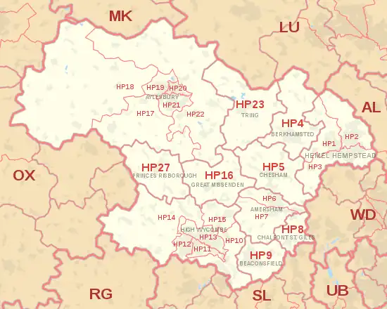
Coverage
The approximate coverage of the postcode districts:
| Postcode district | Post town | Coverage | Local authority area(s) |
|---|---|---|---|
| HP1 | HEMEL HEMPSTEAD | Bourne End, Boxmoor, Chaulden, Fields End, Gadebridge, Great Gaddesden, Nettleden, Piccotts End, Water End, Warner's End | Dacorum |
| HP2 | HEMEL HEMPSTEAD | Gaddesden Row, Piccotts End, Grovehill, Adeyfield, Hemel Hempstead Industrial Estate | Dacorum |
| HP3 | HEMEL HEMPSTEAD | Apsley, Bovingdon, Felden, Flaunden, Hemel Hempstead, Leverstock Green | Dacorum |
| HP4 | BERKHAMSTED | Berkhamsted, Dagnall, Dudswell, Little Gaddesden, Northchurch, Potten End, Ringshall | Dacorum, Buckinghamshire |
| HP5 | CHESHAM | Chesham, Ashley Green, Bellingdon, Botley, Chartridge, Hawridge, Latimer, Lye Green, Newtown, Waterside, Whelpley Hill | Buckinghamshire |
| HP6 | AMERSHAM | Amersham (north), Chesham Bois, Hyde Heath, Little Chalfont (north) | Buckinghamshire |
| HP7 | AMERSHAM | Amersham (south), Coleshill, Little Chalfont (west and centre), Little Missenden, Penn Street, Winchmore Hill | Buckinghamshire |
| HP8 | CHALFONT ST. GILES | Chalfont St Giles, Little Chalfont (south) | Buckinghamshire |
| HP9 | BEACONSFIELD | Beaconsfield, Forty Green, Holtspur, Jordans, Knotty Green, Seer Green | Buckinghamshire |
| HP10 | HIGH WYCOMBE | High Wycombe, Flackwell Heath, Handy Cross, Hedsor, Loudwater, Penn, Tylers Green, Wooburn, Wooburn Green, Wooburn Moor | Buckinghamshire |
| HP11 | HIGH WYCOMBE | Wycombe Marsh | Buckinghamshire |
| HP12 | HIGH WYCOMBE | High Wycombe, Booker, Sands | Buckinghamshire |
| HP13 | HIGH WYCOMBE | High Wycombe, Downley, Totteridge | Buckinghamshire |
| HP14 | HIGH WYCOMBE | Beacon's Bottom, Bledlow Ridge, Bolter End, Bradenham, Cadmore End, Hughenden Valley, Ibstone, Lane End, Naphill, Northend, Stokenchurch, The City, Upper North Dean, West Wycombe | Buckinghamshire |
| HP15 | HIGH WYCOMBE | Cryers Hill, Great Kingshill, Hazlemere, Holmer Green, Hughenden Valley | Buckinghamshire |
| HP16 | GREAT MISSENDEN | Great Missenden, Ballinger, The Lee, Little Hampden, Little Kingshill, Prestwood, South Heath | Buckinghamshire |
| HP17 | AYLESBURY | Aston Sandford, Bishopstone, Butler's Cross, Dinton, Dorton, Ellesborough, Ford, Great and Little Kimble, Kingsey, Haddenham, Meadle, Nash Lee, Stone, Upton, Westlington | Buckinghamshire |
| HP18 | AYLESBURY | Ashendon, Berryfields, Boarstall, Brill, Chearsley, Chilton, Cuddington, Dorton, Easington, Edgcott, Grendon Underwood, Ickford, Kingswood, Long Crendon, Lower Winchendon, Ludgershall, Oakley, Shabbington, Upper Winchendon, Waddesdon, Westcott, Worminghall, Wotton Underwood | Buckinghamshire |
| HP19 | AYLESBURY | Aylesbury, Berryfields, Buckingham Park, Fairford Leys, Prebendal Farm, Quarrendon, Watermead | Buckinghamshire |
| HP20 | AYLESBURY | Aylesbury, Aylesbury Town Centre, Broughton, Elmhurst | Buckinghamshire |
| HP21 | AYLESBURY | Aylesbury, Bedgrove, Elm Farm, Queens Park, Southcourt, Walton, Walton Court | Buckinghamshire |
| HP22 | AYLESBURY | Aston Abbotts, Aston Clinton, Bierton, Buckland, Drayton Beauchamp, Dunsmore, Halton, Hardwick, Hulcott, North Lee, Nup End, Oving, Pitchcott, Quainton, Rowsham, Stoke Mandeville, Weedon, Wendover, Weston Turville, Whitchurch, Wingrave | Buckinghamshire |
| HP22 | PRINCES RISBOROUGH | non-geographic[3][4] | |
| HP23 | TRING | Aldbury, Buckland Common, Cholesbury, Hastoe, Long Marston, Marsworth, New Mill, Puttenham, St Leonards, Tring, Wigginton, Wilstone | Dacorum, Buckinghamshire |
| HP27 | PRINCES RISBOROUGH | Askett, Bledlow, Ilmer, Lacey Green, Longwick, Loosley Row, Monks Risborough, Owlswick, Pitch Green, Princes Risborough, Saunderton, Speen | Buckinghamshire |
Map
Template:Attached KML/HP postcode area
KML is from Wikidata
References
- "ONS Postcode Directory Version Notes" (ZIP). National Statistics Postcode Products. Office for National Statistics. May 2020. Table 2. Retrieved 19 June 2020. Coordinates from mean of unit postcode points, "Code-Point Open". OS OpenData. Ordnance Survey. February 2012. Retrieved 21 April 2012.
- Royal Mail, Address Management Guide, (2004)
- "Non Geographic Codes" (PDF). Royal Mail Address Management Unit. July 2012. Archived from the original (PDF) on 16 September 2012. Retrieved 20 December 2012.
- "New sectors and localities to 14 December 2012" (PDF). Royal Mail Address Management Unit. 20 December 2012. Archived from the original (PDF) on 2 February 2015. Retrieved 20 December 2012.
External links
This article is issued from Wikipedia. The text is licensed under Creative Commons - Attribution - Sharealike. Additional terms may apply for the media files.