LS postcode area
The LS postcode area, also known as the Leeds postcode area,[2] is a group of 29 postcode districts in England, within six post towns. These cover northern West Yorkshire (including Leeds, Wetherby, Pudsey, Otley and Ilkley) and some parts of North Yorkshire (including Tadcaster).
Template:Attached KML/LS postcode area
KML is from Wikidata
Leeds | |
|---|---|
 LS | |
| Coordinates: 53.823°N 1.554°W | |
| Country | United Kingdom |
| Postcode area | LS |
| Postcode area name | Leeds |
| Post towns | 6 |
| Postcode districts | 32 |
| Postcode sectors | 150 |
| Postcodes (live) | 21,561 |
| Postcodes (total) | 31,805 |
| Statistics as at May 2020[1] | |
Coverage
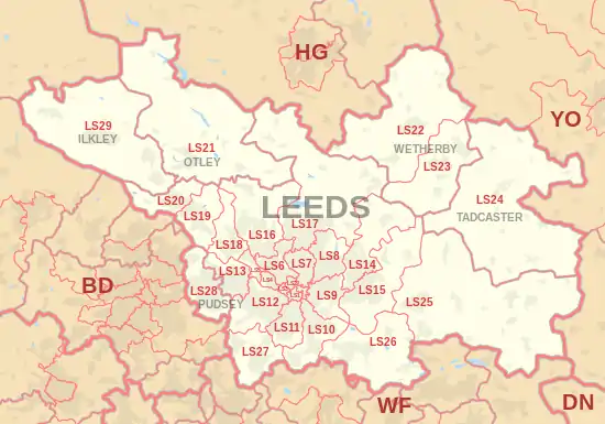
The approximate coverage of the postcode districts:
| Postcode district | Post town | Coverage | Local authority area(s) |
|---|---|---|---|
| LS1 | LEEDS | Leeds city centre | Leeds |
| LS2 | LEEDS | Leeds city centre, Woodhouse | Leeds |
| LS3 | LEEDS | Burley, Woodhouse | Leeds |
| LS4 | LEEDS | Burley, Kirkstall | Leeds |
| LS5 | LEEDS | Hawksworth, Kirkstall | Leeds |
| LS6 | LEEDS | Beckett Park, Burley, Headingley, Hyde Park, Meanwood, Woodhouse | Leeds |
| LS7 | LEEDS | Beck Hill, Buslingthorpe, Chapel Allerton, Chapeltown, Little London, Lovell Park, Meanwood, Miles Hill, Potternewton, Scott Hall, Sheepscar | Leeds |
| LS8 | LEEDS | Fearnville, Gipton, Gledhow, Harehills, Oakwood, Roundhay, Moortown, | Leeds |
| LS9 | LEEDS | Burmantofts, Cross Green, East End Park, Gipton, Harehills, Mabgate, Osmondthorpe, Richmond Hill, Halton Moor | Leeds |
| LS10 | LEEDS | Belle Isle, Hunslet, Leeds city centre, Middleton, Stourton | Leeds |
| LS11 | LEEDS | Leeds city centre, Beeston, Beeston Hill, Cottingley, Holbeck | Leeds |
| LS12 | LEEDS | Armley, Farnley, New Farnley, Wortley | Leeds |
| LS13 | LEEDS | Bramley, Gamble Hill, Moorside, Rodley, Swinnow | Leeds |
| LS14 | LEEDS | Fearnville, Killingbeck, Seacroft, Scarcroft, Swarcliffe, Thorner, Whinmoor | Leeds |
| LS15 | LEEDS | Austhorpe, Barwick-in-Elmet, Colton, Cross Gates, Halton, Halton Moor, Manston, Pendas Fields, Scholes, Temple Newsam, Whitkirk, Killingbeck, Swarcliffe | Leeds |
| LS16 | LEEDS | Adel, Bramhope, Cookridge, Eccup, Far Headingley, Holt Park, Ireland Wood, Lawnswood, Moor Grange, Tinshill, Weetwood, West Park | Leeds |
| LS17 | LEEDS | Alwoodley, Bardsey, East Keswick, Eccup, Harewood, Moortown, Shadwell, Slaid Hill, Weardley, Wike | Leeds, North Yorkshire |
| LS18 | LEEDS | Horsforth | Leeds |
| LS19 | LEEDS | Carlton, Rawdon, Yeadon | Leeds |
| LS20 | LEEDS | Guiseley, Hawksworth | Leeds |
| LS21 | OTLEY | Arthington, Otley, Pool, Blubberhouses | Leeds, North Yorkshire |
| LS22 | WETHERBY | Collingham, Linton, Wetherby | Leeds, North Yorkshire |
| LS23 | WETHERBY | Boston Spa, Bramham, Clifford, Thorp Arch, Walton | Leeds, North Yorkshire |
| LS24 | TADCASTER | Saxton, Stutton, Ulleskelf, Church Fenton, Oxton, Tadcaster, Toulston, Wighill, Ryther cum Ossendyke | North Yorkshire |
| LS25 | LEEDS | Aberford, Garforth, Hillam, Kippax, Ledsham, Micklefield, Monk Fryston, Sherburn-in-Elmet, South Milford | Leeds, North Yorkshire |
| LS26 | LEEDS | Great Preston, Methley, Mickletown, Oulton, Rothwell, Swillington, Woodlesford | Leeds |
| LS27 | LEEDS | Churwell, Gildersome, Morley | Leeds |
| LS28 | PUDSEY | Bagley, Calverley, Farsley, Fulneck, Pudsey, Stanningley | Leeds |
| LS29 | ILKLEY | Addingham, Ben Rhydding, Burley in Wharfedale, Burley Woodhead, Denton, Ilkley, Menston, Middleton | Bradford, Leeds, North Yorkshire |
| LS88 | LEEDS | Jobcentre Plus | Non-geographic |
| LS98 | LEEDS | First Direct | Non-geographic |
| LS99 | LEEDS | PO Boxes | Non-geographic |
Map
Template:Attached KML/LS postcode area
KML is from Wikidata
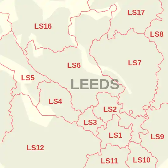
Detailed map of postcode districts in central Leeds
References
- "ONS Postcode Directory Version Notes" (ZIP). National Statistics Postcode Products. Office for National Statistics. May 2020. Table 2. Retrieved 19 June 2020. Coordinates from mean of unit postcode points, "Code-Point Open". OS OpenData. Ordnance Survey. February 2012. Retrieved 21 April 2012.
- Royal Mail, Address Management Guide, (2004)
External links
| Topics |
| ||||||||||||
|---|---|---|---|---|---|---|---|---|---|---|---|---|---|
| Events |
| ||||||||||||
| Culture |
| ||||||||||||
| Politics |
| ||||||||||||
| Transport |
| ||||||||||||
| Sport |
| ||||||||||||
| Parks, gardens & squares |
| ||||||||||||
| Areas |
| ||||||||||||
| |||||||||||||
This article is issued from Wikipedia. The text is licensed under Creative Commons - Attribution - Sharealike. Additional terms may apply for the media files.