S postcode area
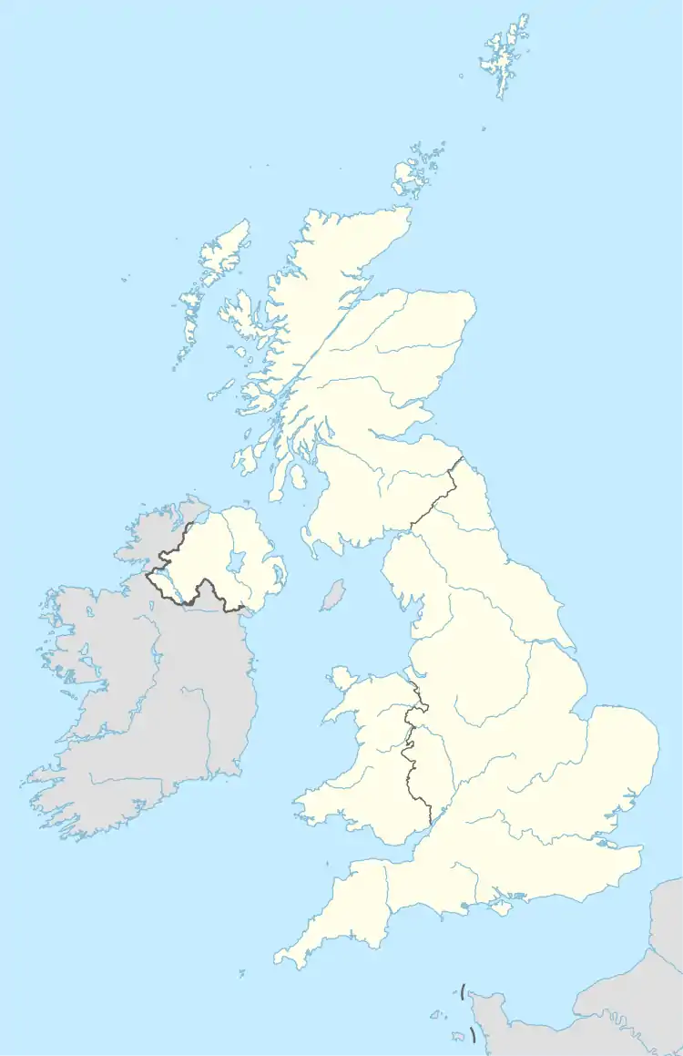
The S postcode area, also known as the Sheffield postcode area,[2] is a group of postcode districts in England, which are subdivisions of eight post towns. These cover most of South Yorkshire (including Sheffield, Barnsley, Rotherham and Mexborough), parts of north Derbyshire (including Chesterfield, Dronfield and the Hope Valley) and north-west Nottinghamshire (including Worksop), plus a small part of West Yorkshire. The S postcode area is one of six with a population above 1 million.[3]
Sheffield | |
|---|---|
 S | |
| Coordinates: 53.397°N 1.407°W | |
| Country | United Kingdom |
| Postcode area | S |
| Postcode area name | Sheffield |
| Post towns | 8 |
| Postcode districts | 52 |
| Postcode sectors | 248 |
| Postcodes (live) | 33,439 |
| Postcodes (total) | 49,099 |
| Statistics as at May 2020[1] | |
History
For 1857–1868 an S sector of the London postal district existed.
Similarly, there were also S-prefixed postal districts in the compass-based system used in Glasgow: Glasgow S1, S2, S3 and S4, which later became G41 to G44.
Three postcode districts were split and separated into ten new postcode districts. These were:
- S20, formed out of S19
- S21, S25 and S26, formed out of S31
- S32 to S36, formed out of S30.
The S64 district covering the Mexborough post town was originally earmarked for use as DN13, which has never been used.
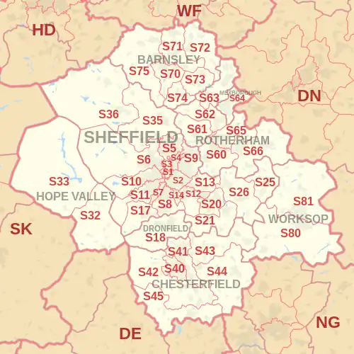
Coverage
The approximate coverage of the postcode districts:
| Postcode district | Post town | Coverage | Local authority area(s) |
|---|---|---|---|
| S1 | SHEFFIELD | City Centre | Sheffield |
| S2 | SHEFFIELD | City Centre, Arbourthorne, Heeley, Highfield, Lowfield, Manor, Newfield Green, Norfolk Park, Park Hill, Wybourn | Sheffield |
| S3 | SHEFFIELD | City Centre, Broomhall, Burngreave, Neepsend, Netherthorpe, Pitsmoor | Sheffield |
| S4 | SHEFFIELD | Brightside, Burngreave, Grimesthorpe, Osgathorpe, Page Hall, Pitsmoor | Sheffield |
| S5 | SHEFFIELD | Firth Park, Fir Vale, Longley, Shirecliffe, Shiregreen, Southey, Parson Cross, Wincobank | Sheffield |
| S6 | SHEFFIELD | Bradfield, Dungworth, Fox Hill, Hillsborough, Holdworth, Hollow Meadows, Loxley, Malin Bridge, Middlewood, Stannington, Storrs, Upperthorpe, Wadsley, Wadsley Bridge, Walkley, Wisewood | Sheffield |
| S7 | SHEFFIELD | Beauchief, Carter Knowle, Millhouses, Nether Edge | Sheffield |
| S8 | SHEFFIELD | Batemoor, Beauchief, Greenhill, Jordanthorpe, Lowedges, Meadowhead, Meersbrook, Norton, Norton Lees, Woodseats | Sheffield |
| S9 | SHEFFIELD | Attercliffe, Brightside, Darnall, Handsworth Hill, Meadowhall, Tinsley, Wincobank | Sheffield |
| S10 | SHEFFIELD | Broomhall, Broomhill, Crookes, Crookesmoor, Crosspool, Endcliffe, Fulwood, Ranmoor | Sheffield |
| S11 | SHEFFIELD | Bents Green, Carter Knowle, Ecclesall, Greystones, Millhouses, Nether Edge, Parkhead, Ringinglow, Sharrow, Whirlow | Sheffield |
| S12 | SHEFFIELD | Frecheville, Gleadless, Hackenthorpe, Intake, Ridgeway | North East Derbyshire, Sheffield |
| S13 | SHEFFIELD | Handsworth, Normanton Spring, Orgreave, Richmond, Woodhouse, Woodthorpe | Rotherham, Sheffield |
| S14 | SHEFFIELD | Gleadless Valley | Sheffield |
| S17 | SHEFFIELD | Bradway, Dore, Totley | Sheffield |
| S18 | DRONFIELD | Dronfield, Holmesfield, Unstone | North East Derbyshire |
| S19 | Recoded to S20 | ||
| S20 | SHEFFIELD | Beighton, Crystal Peaks, Halfway, Mosborough, Owlthorpe, Plumbley, Sothall, Waterthorpe, Westfield | Sheffield |
| S21 | SHEFFIELD | Eckington, Killamarsh, Marsh Lane, Middle Handley, Renishaw, Spinkhill, Troway, West Handley | North East Derbyshire |
| S25 | SHEFFIELD | Anston, Brookhouse, Dinnington, Laughton en le Morthen, Slade Hooton | Rotherham |
| S26 | SHEFFIELD | Aston, Aughton, Harthill, Kiveton Park, Swallownest, Todwick, Ulley, Wales, Waleswood, Woodall | Rotherham |
| S30 | Recoded to S32, S33, S35, S36 | ||
| S31 | Recoded to S21, S25, S26 | ||
| S32 | HOPE VALLEY | Abney, Bretton, Calver, Curbar, Eyam, Foolow, Grindleford, Hathersage, Leam, Stoney Middleton | Derbyshire Dales |
| S33 | HOPE VALLEY | Aston, Bamford, Barber Booth, Bradwell, Castleton, Edale, Hope, Thornhill, Yorkshire Bridge | High Peak |
| S35 | SHEFFIELD | Chapeltown, Crane Moor, Ecclesfield, Green Moor, Grenoside, Hermit Hill, High Green, Oughtibridge, Thurgoland, Wharncliffe Side, Wortley, Worrall | Sheffield |
| S36 | SHEFFIELD | Bolsterstone, Carlecotes, Catshaw, Crow Edge, Deepcar, Dunford Bridge, Hoylandswaine, Ingbirchworth, Langsett, Midhopestones, Millhouse Green, Oxspring, Snowden Hill, Stocksbridge, Penistone, Thurlstone, Upper Midhope, Wigtwizzle | Barnsley, Sheffield |
| S40 | CHESTERFIELD | Town Centre, Boythorpe, Birdholme, Brampton | Chesterfield |
| S41 | CHESTERFIELD | Corbriggs, Hasland, Newbold, Old Whittington, Sheepbridge, Spital, Tapton, Whittington Moor, Winsick | Chesterfield, North East Derbyshire |
| S42 | CHESTERFIELD | Alton, Cutthorpe, Eastmoor, Grassmoor, Holmewood, Holymoorside, Ingmanthorpe, North Wingfield, Temple Normanton, Tupton, Wadshelf, Walton, Wingerworth | Chesterfield, North East Derbyshire |
| S43 | CHESTERFIELD | Barlborough, Barrow Hill, Brimington, Clowne, Hollingwood, Inkersall Green, Poolsbrook, Mastin Moor, Staveley | Bolsover, Chesterfield |
| S44 | CHESTERFIELD | Arkwright Town, Ault Hucknall, Bolsover, Calow, Doe Lea, Heath, Oxcroft, Rowthorne, Scarcliffe, Shuttlewood, Stanfree, Stansby, Sutton cum Duckmanton, Sutton Scarsdale | Bolsover, North East Derbyshire |
| S45 | CHESTERFIELD | Ashover, Astwith, Clay Cross, Hardstoft, Kelstedge, Littlemoor, Milltown, Pilsley, Slack, Uppertown | North East Derbyshire |
| S49 | CHESTERFIELD | Bulk users | non-geographic |
| S60 | ROTHERHAM | Town Centre, Brinsworth, Catcliffe, Canklow, Clifton, Masbrough, Treeton, Waverley, Whiston | Rotherham |
| S61 | ROTHERHAM | Greasbrough, Kimberworth, Rockingham, Scholes, Thorpe Hesley | Rotherham |
| S62 | ROTHERHAM | Abdy, Nether Haugh, Parkgate, Rawmarsh, Wentworth | Rotherham |
| S63 | ROTHERHAM | Bolton-on-Dearne, Goldthorpe, Thurnscoe, Brampton Bierlow, Wath-on-Dearne, West Melton | Barnsley, Rotherham |
| S64 | MEXBOROUGH | Adwick Upon Dearne, Kilnhurst, Mexborough, Swinton | Doncaster, Rotherham |
| S65 | ROTHERHAM | Dalton, East Dene, Eastwood, Herringthorpe, Hooton Roberts, Ravenfield, Thrybergh | |
| S66 | ROTHERHAM | Braithwell, Bramley, Brampton-en-le-Morthen, Hellaby, Maltby, Micklebring, Morthen, Stainton, Stone, Thurcroft, Wickersley | Rotherham |
| S70 | BARNSLEY | Town Centre, Birdwell, Kendray, Stairfoot, Worsborough | Barnsley |
| S71 | BARNSLEY | Ardsley, Athersley, Lundwood, Monk Bretton, Royston | Barnsley |
| S72 | BARNSLEY | Brierley, Cudworth, Grimethorpe, Shafton, South Hiendley | Barnsley, Wakefield |
| S73 | BARNSLEY | Darfield, Hemingfield, Wombwell | Barnsley, Rotherham |
| S74 | BARNSLEY | Elsecar, Hoyland, Jump | Barnsley |
| S75 | BARNSLEY | Barugh Green, Cawthorne, Darton, Dodworth, Gawber, Kexborough, Mapplewell, Pogmoor, Staincross, Tankersley, Wilthorpe | Barnsley, Wakefield |
| S80 | WORKSOP | Worksop (south), Creswell, Rhodesia, Thorpe Salvin, Whitwell | Bassetlaw, Bolsover, Rotherham |
| S81 | WORKSOP | Worksop (north), Blyth, Carlton-in-Lindrick, Langold, Shireoaks, Woodsetts | Bassetlaw, Rotherham |
| S94 | SHEFFIELD | Census 2021 (a main national office) | non-geographic |
| S95 | SHEFFIELD | Bulk users | non-geographic |
| S96 | SHEFFIELD | Bulk users | non-geographic |
| S97 | ROTHERHAM, SHEFFIELD | Bulk users, mostly Selectapost | non-geographic |
| S98 | SHEFFIELD | Bulk users | non-geographic |
| S99 | SHEFFIELD | Jobcentre Plus | non-geographic |
Map
References
- "ONS Postcode Directory Version Notes" (ZIP). National Statistics Postcode Products. Office for National Statistics. May 2020. Table 2. Retrieved 19 June 2020. Coordinates from mean of unit postcode points, "Code-Point Open". OS OpenData. Ordnance Survey. February 2012. Retrieved 21 April 2012.
- Royal Mail, Address Management Guide, (2004)
- "FOI request: Population for every postcode district in England and Wales". The National Archives. Archived from the original on 5 January 2016. Retrieved 26 April 2021.
{{cite web}}: CS1 maint: bot: original URL status unknown (link)